|
||

|

|
|

|
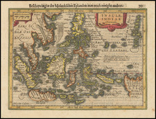
One of the Earliest Obtainable Maps of Manila / Luzon / Northern Philippines
Nice example of Joris van Spilbergen's rare regional map / sea chart of Southern Luzon, Mindoro and Samar Islands, published in Amsterdam in 1619.
The map provides a detailed image of the galleon route through the San Bernardo Channel from the Pacific Ocean and the passage to Manila. Van Spilbergen first arrived with a fleet of 5 ships off the coast of Luzon on February 19, 1616, just days after the departure of the Spanish Armada for the Straits of Singapore. Van Spilbergen arrived in Manila in March, 1616, with intent to plunder Chinese trading ships in Manila Bay in April. However, after 10 days in Manila bay and after hearing rumors of the Spanish intent to attack the Dutch positions in the Moluccas, Van Spilbergen set sail for the Spice Islands to aid in the defense of the Dutch East India Company positions in the region.
The map includes rhumblines and shows Spilbergen's six ships outside Manila Bay and again midway the through the "Fretum Manila alias Estrecho de Manila".
Joris van Spilbergen
Joris van Spilbergen (1568-1620) sailed from Texel in August 1614 with 800 men aboard six ships. Although his voyage was sponsored by the VOC, with a merchant aboard each ship, this was a privateering voyage. Landing first in Brazil, the fleet went on to sail through the Straits of Magellan and into the Pacific. Travelling up the coast of South America towards Acapulco, Spilbergen raided Spanish settlements along the way. One of his biggest his prizes was a pearl fishing vessel the San Francisco captured at Zacatula, just North of Acapulco
Crossing the Pacific to the Mariana Islands and then Philippine Islands, Spilbergen continued to harass Spanish ships, netting a considerable amount of prize money before arriving in Batavia in September 1616. Transferring to the Amsterdam for the voyage home via the Cape of Good Hope, Spilbergen was accompanied by Le Maire and Schouten who had been tried for infringing the VOC’s monopoly.

![Asiatic Archipelago [Early Singapore Inset]](https://storage.googleapis.com/raremaps/img/small/66879.jpg)