|
||

|

|
|

|
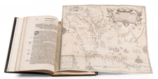
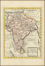
Very Rare Map Showing European Factories on the Lower Ganges River, including the Short-Lived Ostend Company
Detailed and very rare map showing the Hooghly [Hugli] River, and coastal regions on the border between what is today India and Bangladesh. The map shows the outposts of the English, Danish, and French East India Companies, as well as the formidable and freshly minted Ostend Company in the Bengal region.
The west-oriented map shows the winding Hooghly river, a distributary of the Ganges River, as it flows into the Gulf [Bay] of Bengal and the Indian Ocean. The large river, and many smaller streams, irrigate the lush landscape. Stands of trees, fields, and rolling hills fill the inland space.
Many settlements dot the area, grouped mainly around the rivers. These towns and cities are designated by small buildings of varying size and detail, with larger clusters showing the larger population centers. Some of these are the factories where the European powers set up trading outposts.
As you proceed upstream from the Bay of Bengal, one building symbol is different from all the rest. This is the English factory at “Coullicaffa”. Today, this is Calcutta, one of the largest cities in the world. Proceeding farther upstream, a smaller river proceeds east toward the bottom of the map. On this waterway are Hitsiapour [Hydisiapore] and Bankesbasar [Banquibazar, now Ichapore]. The latter was the Ostend Company’s base of operations, while the former contained the “Loge Flamande”, or the Flemish Lodge. Nearby is the French factory at Chandernagar [Chandannagar] and the Danish Lodge at Danemarnagor [Danemarnagore, now Gondalpara]. The latter was closed in 1714 but still appears on this map.
The aforementioned Ostend Company is the subject of this map and one of its employees, Jacques André Cobbé, provided much of the information for it. Cobb’s fate is explained in a cartouche to the right, while a dedication to him is in another cartouche at the bottom. This second cartouche is surrounded by an idyllic profile of the river and surrounding countryside, melding into the picturesque map above and suggesting that this region was a prosperous and fertile one.
The Ostend Company and European trade in Bengal
The Ostend Company was the Indian trading monopoly of the Austrian Netherlands. In 1714, The Holy Roman Empire, ruled by the Habsburgs, received the former Spanish Netherlands in the Treaty of Rastatt. Today, the area forms Belgium and much of Luxembourg.
Charles VI, the Holy Roman Emperor, sought to use the new holdings to compete with the Dutch, French, and English East India Companies. The Ostend Company received its charter in 1722; it was to control the trade with Bengal and was financed by the rich merchants of Antwerp and Ghent. The company’s ships sailed from Ostend, but its offices were in Antwerp, where seven directors oversaw operations.
In India, the Ostend Company has two factories. One was on the Coromandel Coast and the other was Banquibazar, which is shown on this map. The Ostend Company and its rivals were interested in Bengal because of the rich textiles they could acquire there. Between 1724 and 1732, 21 Ostend Company ships were sent to the East Indies, with the majority stopping in Bengal; although young, the new company was proving steep competition for their rivals in France, Britain, and the northern Netherlands.
At Banquibazar, the Ostend Company appointed Lieutenant-General Jacques André Cobbé to establish and lead the factory. While a proven military thinker, Cobbé proved to be an unscrupulous leader. Soon after he arrived in factory, Cobbé started to attack Bengali shipping on the Hooghly River. This affront was not allowed to pass and Cobbé had to barricade himself inside the former Danish factory at Danemarnagore, which is also on this map. While under siege from the Nawab’s forces, Cobbé was struck by a cannonball and killed, as explained in the cartouche to the right.
The Ostend Company came to a similarly quick, if not so indecorous end. Its fate was sealed by its success; the British and Dutch felt threatened by the rival company, not least because it employed many former employees of their own companies. In 1727, just after this map was printed, the Emperor suspended his company’s charter. In 1731, he agreed to abolish it in the Second Treaty of Vienna in return for the recognition of his daughter, Maria Theresa, as his rightful heir.
Rarity
This is a very rare and separately issued map of the region. OCLC locates five examples in France, Israel, the United States, and Germany, while there is at least one example in India, at the Kalkriti Archives.
This map is charmingly drawn and very detailed, but it also recounts a crucial moment of world history. Not only does it show the European commercial encounter with Bengal in the early-eighteenth century, but the Ostend Company celebrated here was to be sacrificed in order to maintain the Habsburg dynasty in the form of Maria Theresa, perhaps its most famous, and its final, ruler.
![[Southeast Asia, Philippines & India] Nova Delineatio particularis Apostolicarum Peregrinationum noni Indiarum Apostoli in India Orientali](https://storage.googleapis.com/raremaps/img/small/51679.jpg)