|
||

|

|
|

|
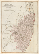
Early trekking map of the northern portion of Central Nepal, focused on the region around Pokhara on the Annapurna Circuit.
The map shows the region in extremely fine detail, with contours, rivers, roads, towns, and more shown. This map was produced locally, in Kathmandu, for the trekkers that started to arrive in the region to explore its natural beauty in the late 20th century.
The map includes an inset map fo Pokhara as well as a second inset map of the route to Bhurjung Khola Valley. Above the map, a geographical section of the track from Pokhara to Jomsom is shown.
Provenance
This map was used by the botanist Oleg Polunin on his travels to the region. Educated at Magdalen, Oxford, and having taught at Charterhouse, he wrote several important texts for students of botany. His early work focused on European flowers, but later he started studying wild flowers in the Himalaya. He was awarded the Linnean Society's H. H. Bloomer Award in 1983, shortly after the publication of this map. He died in 1985.