|
||

|

|
|

|
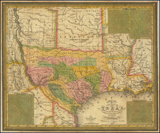
"Texas is, or will be, the wealthiest state in the Union, possessing as she does great agricultural capabilities, all the varieties of soils, minerals and useful rocks known to exist in the world" - A. R. Roessler
One of the greatest of the large format maps of Texas, by the best Texas cartographer of the late 19th century.
The foremost accomplishment of Roessler's map comes in its preservation of considerable geological data about Texas. It substantially exceeds Roemer's Topographisch-geognostische Karte von Texas (the first geological map of Texas) with the key listing 22 mineral and geological points of interest: Iron; Manganese; Copper; Silverlead; Gold; Bismuth; Molybdenite; Sulphate of Iron; Sulphur (Copperas); Salt; Gypsum; Coal; Lignite (Brown Coal); Graphite; Koalin; Pottersclay; Steatite; Mica; Feldspar; Mineral Asphalt; Mineral Springs; Nitre Caves.
Shumard Geological Survey
In 1860, Roessler is first recorded in service in Texas, as he was appointed draftsman for Shumard's Geological Survey. Benjamin Franklin Shumard had headed a section of the geological survey of Iowa, Wisconsin, and Minnesota in 1848 and 1849 and in 1850 accompanied a geological survey to Oregon. Shumard moved to Texas in 1858, to become chief geologist of Texas under appointment of Governor Hardin R. Runnels. Shumard organized the Texas Geological Survey, the first on a comprehensive scale authorized for the state, and appointed as his assistants his brother George G. Shumard, W. P. Riddell, A. R. Roessler, Caleb G. Forshey and Svante Palm. On November 1, 1860, Shumard was removed from office by Governor Sam Houston and despite being temporarily reinstated by the legislature. The Civil War stopped any conclusion of the Geological Survey, and indeed, it was only through Roessler that much of the collected data was preserved.
Roessler did not leave for Union territory like the rest of those involved in the Shumard Survey, for he later emphasized his loyalty to the Confederacy in a bitter quarrel with Samuel Botsford Buckley.
Keith Young in The Handbook of Texas History elaborates considerably:
Roessler's participation in recovering and saving Shumard survey materials resulted in the preservation of some of the fossils and maps. In 1868 he sent to Vienna a collection of supposed Texas fossils, some of which were indeed from Texas; unknown to Roessler, however, and to the confusion of the paleontological world for many years, some items were from Nebraska. Additional fossils, presumed to be Shumard material (although some may have been collected by Roessler himself), were given to the United States National Museum and Columbia University by Roessler. If these fossils were part of the survey collections, Roessler cannot be entirely blamed for salvaging what otherwise would have been lost or destroyed during the war years, when the geological survey rooms were used as a percussion-cap factory.
Roessler's motives for salvaging the survey data for mapmaking are somewhat suspect; but in whatever manner he obtained the data, the maps were mostly published under the banner of the Texas Land and Immigration Company of New York. In addition to geological data of the survey, the maps contained promotional material of a later date. The Shumard survey operated under such adverse political conditions that the maps are no longer of importance except as historical memorabilia.
The lower left corner of the map includes an inset thematic map: Map Showing Agricultural Districts and Varieties of Soils in the State of Texas. This map documents eight different kinds of soils. The map differentiates between the "Wheat Region" the "Mineral and Grazing Country" and the "Cotton Region".
Maximilian van Mittendorfer (fl. 1871-1896) was a New York-based artist, draughtsman, and architect. Mittendorfer is somewhat difficult to track through the historical record, having used many variations on his name throughout his career. His name is given varyingly as Max, M.V., Maximilian V., Maximilian Van, and lastly Maximilian Von Mittendorfer. He first shows up an artist working in Brooklyn in 1871 where he produced an image of Cupid, which was “handsomely lithographed by Julius Schledorn". In that same year, he was elected co-Librarian of the Palette Society, an association of artists and promoters of the arts. He evidently did not find enough work as an artist and quickly transformed himself into a design journeyman, showing up in New York City business directories as a designer, draughtsman, and architect from at least 1871 to at least the mid-1880s. He worked at 83 Nassau Street until moving to 150 Broadway (no more than a five-minute walk from the former location) sometime in the 1880s. Later he moved to 61 Park Place. We have traced three maps in which Mittendorfer had a hand, most importantly A.R. Roessler's map of 1874, followed by another Texas-related map a year later, "Map of Llano County Showing Geology" (Day, Texas Maps, #1524). The third map was evidently made in 1896 for the Hangerman Land Company and was titled “Map of Grand View Park, property of The Hangerman Land Company, situated at Rocky Point, Suffolk County, New York.” Sometime between 1874 and 1880, Mittendorfer signed a petition, along with other New York architects, in favor of using the metric system in the United States. Though Mittendorfer billed himself as a civil engineer ("C.E.") when signing the Roessler map, we have found no external evidence that he was trained or qualified as a civil engineer.