


|
||

|

|
|

|
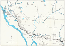
Attractive manuscript plan for an early subdivision in Galveston, Texas, drawn by Galveston-based surveyor R.W. Luttrell.
The map shows a Gulf of Mexico-adjacent 15-block addition called the "Ocean View Addition". The addition is centered around the "G. & W. Ry. Depot" on Galveston Boulevard. Curiously, we cannot identify what the G&W Railway was nor if it was actually an operating railway at this time.
The map names the following streets" Cleveland Ave.; Bayard Ave.; Galveston Boulevard; Douglas Ave.; Taylor Ave.; Williams Ave.; Burgess Ave.; Garrison Street; and Griffing Street. None of these streets can be found on 19th- or 20th-century maps of Galveston, leading to the conclusion that this addition never reached fruition.
The mapmaker, R.W. Luttrell, was active on either side of 1900, and this map was probably produced between roughly 1895 and 1906.

![Map of the Missouri Pacific and St. Louis, Iron Mountain and Southern Railway and Connections [Missouri Pacific Railway. St. Louis & All Points East Chair Cars Free Fast Mail Route]](https://storage.googleapis.com/raremaps/img/small/91606.jpg)
![[Matagorda Bay] Bahia De S. Bernardo](https://storage.googleapis.com/raremaps/img/small/54374.jpg)
![[ Texas Oil Map ] Map of Terrell County Texas](https://storage.googleapis.com/raremaps/img/small/102589.jpg)