|
||

|

|
|

|
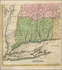
Nice example Carrington Bowles' scarce map of New England, based upon Braddock Mead's 4-sheet map of 1755.
The map is one of the earliest maps to include the names of the townships within New England, a number of which are not yet named. Other interesting annotations include a note in New Hampshire referencing "Wilderness Lands of the Crown not yet appropriated," and observations concerning "French Encroachments" in the region.
The map identifies a number of early forts on the Hudson River, just south of Lake Champlain. Fort Hunter and a reference to William Johnson appear north of Albany. with a road running west of the Hudson River north to Fort William Henry.
This is the third edition of the map, which can be distinguished from earlier editions by the date (1771) and the inclusion of only Carrington Bowles' name.
Rarity
The map has become scarce on the market and is much rarer than the later 4 sheet editions of the Braddock Mead map which appeared in Jefferys American Atlas, beginning in 1775.
![[ Maine ] Carte Geographique, Statistique et Historique Du Maine](https://storage.googleapis.com/raremaps/img/small/79342.jpg)