This item has been sold, but you can enter your email address to be notified if another example becomes available.


|
||

|

|
|

|
Stock# 58962
Description
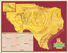
An early blueprint map of Texas, illustrating the location of oil and gas field within the state.
Includes symbols identifying the two types of fields.
The largest drilling concentrations appear in Gonzales County, Kinney County, Jimm Hogg County, Burleson County and Milam County.
![[ Republic of Texas ] Central America II. Including Texas, California and the Northern States of Mexico](https://storage.googleapis.com/raremaps/img/small/93534.jpg)
![(Republic of Texas Land Grants with Maps - Coahuila y Tejas) [Manuscript land grant documents issued by Radford Berry, alcalde of Nacogdoches, to John Adams and others, with manuscript plat maps by Arthur Hendrie and George Aldrich]](https://storage.googleapis.com/raremaps/img/small/88920.jpg)