


|
||

|

|
|

|
A finely detailed map of Holland published in Amsterdam, circa 1700.
The map extends from Amsterdam in the south to Texel in the north, outlining key municipalities and cities across the region, including Goeree-Overflakkee, Voorne-Putten, Utrecht, Rotterdam, Gelderland, Midden-Delfland, IJsselmonde, etc. It also illustrates topographical features such as lakes, mountain ranges, waterways, hills, canals and islands.
A beautifully engraved title cartouche, scale of miles, and two compass roses are also featured on the map.
Pierre, or Pieter, Mortier (1661-1711) was a Dutch engraver, son of a French refugee. He was born in Leiden. In 1690 he was granted a privilege to publish French maps in Dutch lands. In 1693 he released the first and accompanying volume of the Neptune Francois. The third followed in 1700. His son, Cornelis (1699-1783), would partner with Johannes Covens I, creating one of the most important map publishing companies of the eighteenth century.
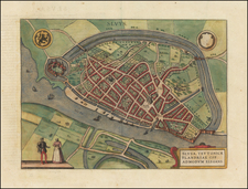
![[Delft]. Delphium urbs Hollandiae cultissima, ab eiusdem nominis fossa vulgo, Deelft appellata](https://storage.googleapis.com/raremaps/img/small/54931mp2.jpg)
![Deutschland un die Niederlande von Bauerkeller [Germany and the Netherlands by Bauerkeller]](https://storage.googleapis.com/raremaps/img/small/88180.jpg)