This item has been sold, but you can enter your email address to be notified if another example becomes available.


|
||

|

|
|

|
Stock# 57437
Description
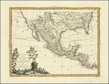
Atinkson's map is one of the earliest maps to delineate the newly declared Republic of Texas, with Austin's Colony separately colored in pink.
The southwestern border between Texas and Mexico follows the Nueces River which was later extended to the Rio Grande.
Locates numerous Indian regions including the Whaco in Texas, Moqui, Navaho, several Apache tribes including the Mescalaros in Chihuahua in Mexico, and many more. In Texas the settlements of San Felipe, Matamoras, Brazaria and Victoria are located.
Sold for the map fragment -- text has not been collated.
An example of the complete map is illustrated here: https://repository.tcu.edu/handle/116099117/11490
Condition Description
Large fragment of Atkinson's map Texas, Mexico, and Part of the United States, plus text.

![[ Texas - Dallas to El Paso ] Flight Chart- Dallas Fort Worth to El Paso, U.S.A.](https://storage.googleapis.com/raremaps/img/small/98371.jpg)
![Map of Texas [with] inset of N.W. Part of Texas](https://storage.googleapis.com/raremaps/img/small/84519.jpg)
![[ Mexican Railroads ] Carta De Comunicaciones De Los Estados Unidos Mexicanos Formada de orden de la Secretaria de Estado y del Despacho de Comunicaciones y Obras Publicas, por el Coronel Bodo von Glumer . . . Primera Hoja. 1895 - 1896. (and) Segunda Hoja 1895 - 1896](https://storage.googleapis.com/raremaps/img/small/103235.jpg)