


|
||

|

|
|

|
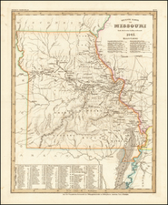
Neueste Karte von Missouri Nach den bessten Quellen verbessert 1845, published by Joseph Meyer in Hildburghausen in 1845, is an elegantly engraved and detailed representation of Missouri. It illustrates the state's counties, towns, roads, mountain ranges (such as they are), rivers, and includes a distinctive table of distances and times for various steamship routes along several rivers. Based on Henry Schenk Tanner's work from the early 1840s, this map represents a significant contribution to the cartographic understanding of the region during the 19th century.
The mid-19th century was a period of extensive exploration, settlement, and development in the United States, particularly in the Midwest. Missouri, as a border state, held a strategic geographical and political position. This map provides a valuable glimpse into the state's landscape and infrastructure at that time, illustrating not only natural features but also human-made elements such as roads and steamship routes, which were crucial for transportation and commerce.
The map, produced in the Geographical Engraving Institute of the Bibliographical Institute in Hildburghausen and distributed in Amsterdam, Paris, and Philadelphia, also symbolizes the international collaboration and dissemination of geographical knowledge during the period. It embodies a confluence of artistic, scientific, and commercial interests that characterized 19th-century cartography.
In summary, Neueste Karte von Missouri Nach den bessten Quellen verbessert 1845 stands as a sophisticated representation of Missouri's geography during a transformative period in American history. It not only serves as a historical document but also as a piece of art, reflecting the intricate relationship between exploration, understanding, and depiction of the land in the 19th century.
Joseph Meyer (1796-1856) was a German publisher who released Meyers Konversations-Lexikon, a German-language encyclopedia in print from 1839 to 1984. Meyer was born in Gotha and educated as a merchant in Frankfurt, an important city in the book trade. He traveled in London in 1816 and was back in German in 1820, where he began to invest in textiles and railways. He opened his publishing operation, Bibliographisches Institut, in 1826. His publications each had a serial number, a new innovation at the time. He was best known for his atlases and the Meyers Universum (1833-1861), which featured steel-engravings of the world. The Universum stretched to 17 volumes in 12 languages and was subscribed to by 80,000 people all over Europe. Thanks to his publishing success, Meyer moved the Institut from Gotha to Hildburghausen in 1828. Meyer died in the latter city in 1856.
![[ Hungarian Traveler In the California and the West with a Comanche and Wichita to Hungarian vocabulary ] Levelei Éjszakamerikából -- Tizenkét eredeti rajzok után készült kő- és egynéhány fametszettel. Közli Prépost István (Letters from North America)](https://storage.googleapis.com/raremaps/img/small/98502.jpg)

![[Run of 6 Volumes] Report Upon Geographical Surveys West of the 100th Meridian](https://storage.googleapis.com/raremaps/img/small/74064.jpg)