


|
||

|

|
|

|
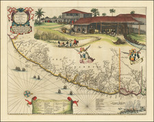
Rare Broadside Map Celebrating The Dutch Capture of The Town of Olinda in Pernambuco by the Dutch West Indies Company in February 1630
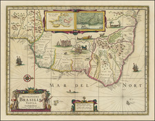
Rare separately published map of coast around Olinada in Portuguese held Pernambuco, published shortly after the successful raids by the Dutch West Indies Company on the Portuguese State of Pernambuco, which led to the capture of the town and transition of the region from a Portuguese colony to a Dutch Colony in 1630.
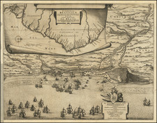
The map depicts naval battle activities of February 1630, illustrating the Dutch attack of the Portuguese held town of Olinda. To the left, the Dutch ships engage the Portuguese fortifications at the mouth of the river, while to the right of Olinda, a large landing force of foot soldiers disembarks and proceeds toward the poorly protected town of Olinda.
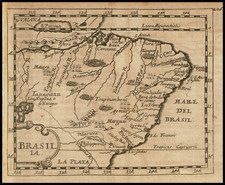
The map includes a large inset map of Brazil and a view of the interior of a sugar mill.
Title cartouche in the lower part of the map, decorated with a native holding a shield with the vignette of the West Indies Company and a dedication to Admiral Hendrick Corneliszoon Lonck, the first Dutch Sea Captain to reach the New World (1606) and the commanding officer in the Dutch West Indies Company's successful raids on the Portuguese held coast of Brazil.
In 1628, Lonck, in the service of the Dutch West Indies Company, joined Admiral Piet Hein in the Battle in the Bay of Matanzas, a naval battle during the Eighty Years' War in which a Dutch squadron was able to defeat and capture a Spanish treasure fleet. Lonck replaced Hein in 1629 as Captain-general. In 1630, he commanded a Dutch colonizing expedition of 52 ships, 15 sloops, and 3,780 sailors that captured the historic city of Olinda, Brazil on on February 14, 1630, followed by the capture of the Brazilian state of Pernambuco after a brief resistance by Matias de Albuquerque, its Portuguese Governor.
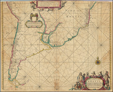
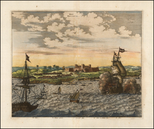
The present map is the central map section of a larger wall map, which includes a large view (at the top) and text panels on the sides and below the present map. A link to the example in the National Library of Brazil can be seen here: https://bndigital.bn.gov.br/artigos/hanc-tabulam-continens-laetam-pharnambuci/
Rarity
While the left side of the map (with inset of Brazil) appears occasionally on the market, the complete 2 sheet map is very rare.
According to Holstein, there are only two known copies of the complete wall map.