|
||

|

|
|

|
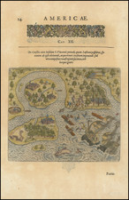
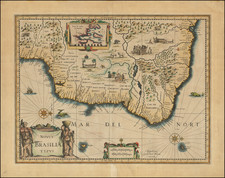
Stunningly detailed map of Brazil, produced by the esteemed cartographers Hondius and Jansson.
Oriented with west at the top, the map depicts the landscape of Brazil with an impressive degree of accuracy and an artistic touch that demonstrates the skilled craftsmanship of the mapmakers.
The map's primary focus is on the coastal and riverine regions, reflecting the major sea routes and ports that were pivotal to the European exploration and colonization during the period, as well as some limited knowledge of the upriver country. It is adorned with intricate rhumb lines that crisscross the contiguous sea, guiding the eye towards the vastness of the sea, and suggesting the navigational paths followed by the seafarers of the time.
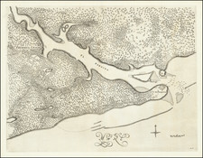
Two inset maps, Baia de Todos Sanctos and Olinda de Pernambuco, are included, each offering a detailed view of these important regions. The insets are meticulously rendered, offering a closer look at the harbors, coastlines, and topographical features.
The map is decorated with a series of engaging vignettes that depict scenes of indigenous life. These vignettes, rich in their representation of local customs and daily life, provide fascinating insights into the native cultures of Brazil during the time of European contact.
Sailing ships are scattered across the ocean, adding a dynamic element that imbues the map with a sense of the bustling maritime activity of the era. These vessels, varying in size and design, evoke the adventurous spirit of the explorers, traders, and colonizers who traversed these waters.
Jan Janssonius (also known as Johann or Jan Jansson or Janszoon) (1588-1664) was a renowned geographer and publisher of the seventeenth century, when the Dutch dominated map publishing in Europe. Born in Arnhem, Jan was first exposed to the trade via his father, who was also a bookseller and publisher. In 1612, Jan married the daughter of Jodocus Hondius, who was also a prominent mapmaker and seller. Jonssonius’ first maps date from 1616.
In the 1630s, Janssonius worked with his brother-in-law, Henricus Hondius. Their most successful venture was to reissue the Mercator-Hondius atlas. Jodocus Hondius had acquired the plates to the Mercator atlas, first published in 1595, and added 36 additional maps. After Hondius died in 1612, Henricus took over publication; Janssonius joined the venture in 1633. Eventually, the atlas was renamed the Atlas Novus and then the Atlas Major, by which time it had expanded to eleven volumes. Janssonius is also well known for his volume of English county maps, published in 1646.
Janssonius died in Amsterdam in 1664. His son-in-law, Johannes van Waesbergen, took over his business. Eventually, many of Janssonius’ plates were sold to Gerard Valck and Pieter Schenk, who added their names and continued to reissue the maps.