


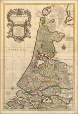
|
||

|

|
|

|
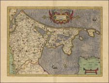
Fine early birdseye view of the Island of Middelburg.
From Braun & Hogenberg's Civitatus Orbis Terrarum, the most important book of town plans and views published in the 16th century.
This bird's-eye view from the southeast shows the capital of Zeeland province, on the Island of Walcheren. The favourable geographical location and an import monopoly on spices, silk cloth and French wines led to Middelburg being granted a town charter as early as 1217, and in the 16th century it was a prosperous trading city with a population of 30,000. The influential Vereenigde Oostindische Compagnie (VOC) had 336 ships built here between 1602 and 1795. The splendid town hall (Stathuys), built in the late Gothic style under Charles the Bold, can be identified on the market square. In front of it stands the Onze-Lieve-Vrouwe abbey with the Choir Church (Koorkerk) dating from around 1300 with its 85-m-high tower, "De Lange Jan".
Georg Braun (1541-1622) was born and died in Cologne. His primary vocation was as Catholic cleric; he spent thirty-seven years as canon and dean at the church St. Maria ad Gradus, in Cologne. Braun was the chief editor of the Civitates orbis terrarum, the greatest book of town views ever published. His job entailed hiring artists, acquiring source material for the maps and views, and writing the text. In this role, he was assisted by Abraham Ortelius. Braun lived into his 80s, and he was the only member of the original team to witness the publication of the sixth volume in 1617.
Frans Hogenberg (ca. 1540-ca. 1590) was a Flemish and German engraver and mapmaker who also painted. He was born in Mechelen, south of Antwerp, the son of wood engraver and etcher Nicolas Hogenberg. Together with his father, brother (Remigius), uncle, and cousins, Frans was one member of a prominent artistic family in the Netherlands.
During the 1550s, Frans worked in Antwerp with the famous mapmaker Abraham Ortelius. There, he engraved the maps for Ortelius’ groundbreaking first atlas, published in Antwerp in 1570, along with Johannes van Deotecum and Ambrosius and Ferdinand Arsenius. It is suspected he engraved the title page as well. Later, Ortelius supported Hogenberg with information for a different project, the Civitates orbis terrarium (edited by Georg Braun, engraved by Hogenberg, published in six volumes, Cologne, 1572-1617). Hogenberg engraved the majority of the work’s 546 prospects and views.
It is possible that Frans spent some time in England while fleeing from religious persecution, but he was living and working in Cologne by 1580. That is the city where he died around 1590. In addition to his maps, he is known for his historical allegories and portraits. His brother, Remigius, also went on to some fame as an engraver, and he died around the same time as his brother.
![Belgium Foederatum auctius et emendatius… [Large inset of SE Asia]](https://storage.googleapis.com/raremaps/img/small/89316.jpg)