


|
||

|

|
|

|
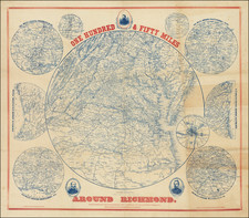
Finely executed plan of the Clifton Forge, Virginia, on the Jackson River, by D. St. George Fraser.
The map would seem to have been issued during a boom period, early in the history of the town and prior to its being chartered in 1906.
The Town of Clifton Forge, Virginia was chartered in 1906, but its history dates back to the 1700s. The land the Town now occupies was originally part of a 1770 land grant to a Robert Gallaspy by Lord Botetourt, the then Governor of Virginia. The ownership of the land changed several times, and the Williamson and Smith families became the owners in the 1820s. A settlement developed along both sides of the Jackson River from Slaughter Pen Hollow to Smith Creek. The iron industry in Alleghany County and the completion of the road over North Mountain (now U.S. Route 60) in 1826 began the growth of the settlement. Mr. William Lyle Alexander of Lexington owned a forge in the Rainbow Gorge near Iron Gate, and he named the forge “Clifton” in honor of his father’s estate in Lexington.
The Town has a rich railroad heritage with the first passenger train arriving in Clifton Forge in 1857. Clifton Forge grew up with the railroad industry and it became a major maintenance facility for steam locomotives of the Chesapeake & Ohio (C&O Railroad). The Town was a virtual boomtown during the heyday of the railroad with the C & O employing nearly 2,000 people.
![[ Washington DC / Virginia / Maryland / Delaware / New Jersey ] Washington Sectional Aeronautical Chart](https://storage.googleapis.com/raremaps/img/small/99620.jpg)
![[ Mount Vernon ] The Kitchen Garden of Mount Vernon, Seat of General George Washington in Viginia, The Design of an Elegant Kitchen and Fruit Garden Containing 0.92 Acres](https://storage.googleapis.com/raremaps/img/small/101604.jpg)