|
||

|

|
|

|
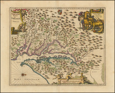
De L'Amerique Figure CXXVI, published by Alain Manesson Mallet in Paris in 1683, offers an intricate depiction of a Powhatan Indian Village and the interior of a Powhatan Lodge, the latter taking inspiration from the representation seen on Smith's map of Virginia. This map is a notable engraved plate from Mallet's eminent work, Description de l' Univers, arguably one of the 17th century's most remarkable endeavors in the realm of cartographic publications.
The late 17th century marked a period of burgeoning European interest in the New World, with colonial powers seeking both territorial expansion and greater understanding of the indigenous cultures they encountered. The Powhatan, native to present-day Virginia, were of particular interest due to their interactions with English settlers. This map captures the European conecption of Powhatan life, juxtaposing their domestic settings with the broader geographical context.
Mallet's commitment to detail in portraying the Powhatan Indian Village and lodge reveals more than just geographical information. It provides a window into the cultural and social nuances of the Powhatan way of life, a representation made all the more significant considering the European curiosity and sometimes misconceptions about indigenous North American tribes. By basing part of his depiction on Smith's map of Virginia, Mallet acknowledged and incorporated prior European engagements with the continent, ensuring a degree of continuity and authenticity in his portrayal.
The broader context of Description de l' Univers cannot be understated. As a seminal work of the 17th century, it stood as a testament to the period's thirst for knowledge and exploration. Within this vast tapestry, De L'Amerique Figure CXXVI emerges as a crucial piece, reflecting the intricate dance between exploration, understanding, and representation during a transformative era in global history.
Alain Mannesson Mallet (1630-1706) was a French mapmaker and engineer who served in the armies of Louis XIV. After rising through the ranks, Mallet was appointed as Inspector of Fortifications, a job which also required mathematical skills and which made him a competent military engineer. Eventually, he joined the court of Louis XIV at Versailles, where he taught math and focused on writing.
Mallet is best known for his Description de L’Univers, first published in 1683, in five volumes. A wide-ranging geographical work, the Description included textual descriptions of the countries of the world, as well as maps of the celestial sky and the ancient and modern worlds. The Description continued to be published until the early eighteenth century. He also published a work in three volumes on warfare (1684) and a primer on geometry (1702).
![(Mexican-Aztec Paintings) [Original watercolor of 4 Aztec Deities:] Atlcaualoc. Tlaloc, God of Water; Tlacaxipeualitztli, God of Soldiers; Tocozintli, God of Abundance; Veitozcoztli, God of First Fruits.](https://storage.googleapis.com/raremaps/img/small/103005.jpg)
![[ The Marks of Sundry of the Chief Men of Virginia ] Aliquot Heroum Virginiae Notae.](https://storage.googleapis.com/raremaps/img/small/98859.jpg)