


|
||

|

|
|

|
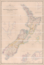
Rare 1869 map of New Zealand’s North Island showing the state of the region during the Taranaki War.
The map illustrates:
- Districts where nearly all natives have joined the rebellion (red)
- Disticts where the majority have joined the rebellion (yellow)
- Districts in which a minority have joined the rebellion (blue)
- Districts in which nearly all natives have not joined the rebellion in northern district or have remained at home (green)
- Districts in which the proportion of rebel and loyal natives is about equal (green spots on a yellow field)
- Disaffected natives living within friendly districts (red spots on a green field)
From a Museum of New Zealand: Te Papa Tongarewa entry on Māori land rights:
The Crown created various laws in the 1860s to allow it to take land. The New Zealand Settlements Act 1863 allowed it to confiscate the land of North Island deemed to have rebelled against the Crown. The Public Works Act 1864 let it take land for roads, railways, and other public works.
The Native Land Court, established in 1865 (and renamed the Māori Land Court in 1954), encouraged Māori to sell land to private buyers. But the Crown remained the biggest purchaser. It on-sold most of its Māori land, often for a profit.
By 1939, almost 100 years after the Treaty was signed, Māori retained just 1 percent of the South Island and 9 percent of the North Island. Land losses continued as the 20th century progressed, again supported by legislation.
The map covers the period of the First and Second Taranaki War and Titokwaru's War.
Rarity
The map is very rare on the market. This is the first example we have ever seen offered for sale.
![[ New Zealand ] To the Right Honourable The Secretary of State for the Colonies &c. &c. &c. This Chart of New Zealand, from Original Surveys . . . Third Edition . . .](https://storage.googleapis.com/raremaps/img/small/70538.jpg)
![[ New Zealand ] Partie De La Nle. Zelande. Oceanique No. 59 [with] Partie De La Nle. Zelande. Oceanique No. 60](https://storage.googleapis.com/raremaps/img/small/74654.jpg)
