|
||

|

|
|

|
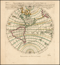
Exceptionally Rare and Striking Seventeenth-Century Wall Map of the World by Cornelis Danckerts
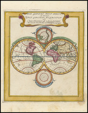
Stunning, old-color example of this exceedingly rare four-sheet wall map of the world, published in Amsterdam by Cornelis Danckerts. This is only the second example known.
The present example is an extraordinary survival, being an earlier state of a wall map previously recorded in a single, later state by Johannes Van Keulen and held at the University of Leiden. Rodney Shirley posited that the map likely existed in earlier states and this is the first evidence to support that hypothesis. The present survival is made all the more remarkable by the extraordinarily bold original color, as most seventeenth-century wall maps typically have severely faded or broken color remnants.
The map was most likely initially published by Frederick de Wit in the mid-1660s. Shirley suspects that it was the result of a collaboration of de Wit and Romeyn de Hooghe, who here did reduced versions of the border decorations that are on de Wit’s maritime world map of 1668.
Then, in ca. 1696, Danckerts issued this state, which includes a dedicatory portrait to Principi Wilhelmo III. This refers to King William III of England, also known as Prince Wilhem Hendrik of Orange.
Danckerts’ address in the cartouche in the South Indian Ocean helps to date this state. The Cornelis Danckerts identified on the map would be Cornelis II (1664-1717), the grandson of Cornelis Danckerts the Elder and son of Justus Danckerts. The map cartouche lists the address of the prominent bookbinder Albertus Magnus, who had died in 1689. Danckerts married Magnus’ daughter, Geertrui, in 1696 and moved into the Widow Magnus’ premises on the “Nieuwendijk in den Atlas.” 1696 was also the year that William became Stadtholder of Drenthe, which may have spurred the re-issuance of the map.
The map is arresting in its compelling geographic and decorative composition. The double-hemisphere world map is augmented by two polar insets. The southern polar inset shows only Tierra del Fuego, highlighting how little verified information existed about the far southern latitudes. In the north, Greenland seems to approach the pole and is connected to North Americas, making an open-water Northwest Passage unlikely, although a Northeast Passage is still possible.
In the western hemispheres, California is shown as an island. There is a single huge lake where the Great Lakes are. The Strait of Anian makes inroads to the interior of the continent in the Pacific Northwest, suggesting a riverine Northwest Passage.
In the Pacific, New Zealand is shown as a fragmented coast. Farther north, the North Pacific chimeras are evident. Yedso, an exaggerated representation of Hokkaido, is near Staten and Compagnies Land, both of which were discovered in the 1640s when Dutch ships were searching for another mythical land, de Gama’s Land.
In the eastern hemisphere, China is scarred by a huge, snaking Xano Desert. This was a feature that appeared on the maps of Visscher, who de Wit used as a model. The Great Wall of China is also marked. Australia is connected to New Guinea. Its toponyms come from Dutch interactions with the Australian coast throughout the seventeenth century.
The decorative border is also an important part of the map. Each of the four corners represents one of the four elements. In the top left is fire, shown as a powerful explosion in the fog of war. Continuing clockwise, air is a represented as a celestial scene with numerous birds and classical deities. Water features Poseidon being worshiped with ships sailing in the background, while earth’s corner is a pastoral scene.
William of Orange
William III and II (1650-1702) was born in Binnenhof Palace in the Hague, the only child of William II, Prince of Orange, and his consort, Mary, eldest daughter of Charles I. Although his family was struck by setbacks and weakened by republicanism at the time of William’s birth, by 1672 he had been restored to his offices and was leading the Dutch lands against the threat of French invasion.
In 1677, William married Mary, daughter of the future James II and William’s first cousin. In late 1688, William invaded his father-in-law’s kingdom and took power as ruler of England, Scotland, and Ireland, along with Mary. She died, however, in 1694, leaving William to rule alone until his death in 1702.
Rarity
This is the only known example of this state of the map. A single example of a later van Keulen state exists at the University of Leiden, as noted above.
This strait, believed to separate northwestern America from northeastern Asia, was related to the centuries-long quest to find a Northwest Passage connecting the Atlantic Ocean to the Pacific. The rumor of this strait and a Northwest Passage in general inspired many voyages of discovery, including those of John Cabot, Sir Francis Drake, Gaspar Corte-Real, Jacques Cartier, and Sir Humphrey Gilbert.
The term Anian itself comes from Marco Polo’s thirteenth-century accounts of his travels. Polo used the term to refer to the Gulf of Tonkin, but cartographers thought it could refer to this supposed strait between Asia and North America. The Strait of Anian, so named, first appeared in a 1562 map by Giacomo Gastaldi, and was later adopted by Bolognini Zaltieri and Gerard Mercator.
North Pacific chimeras: Yesso, De Gama, and Compagnie Land
The etymology of the idiom Yesso (Eso, Yeco, Jesso, Yedso) is most likely the Japanese Ezo-chi; a term used for the lands north of the island of Honshu. During the Edō period (1600-1886), it came to represent the ‘foreigners’ on the Kuril and Sakhalin islands. As European traders came into contact with the Japanese in the seventeenth century, the term was transferred onto European maps, where it was often associated with the island of Hokkaido. It varies on maps from a small island to a near-continent sized mass that stretches from Asia to Alaska.
The toponym held interest for Europeans because the island was supposedly tied to mythic riches. Father Francis Xavier (1506-1552), an early Jesuit missionary to Japan and China, related stories that immense silver mines were to be found on a secluded Japanese island; these stories were echoed in Spanish reports. The rumors became so tenacious and tantalizing that Abraham Ortelius included an island of silver north of Japan on his 1589 map of the Pacific.
Yesso is often tied to two other mythical North Pacific lands, Gamaland and Compagnies Land. Juan de Gama, the grandson of Vasco de Gama, was a Portuguese navigator who was accused of illegal trading with the Spanish in the East Indies. Gama fled and sailed from Macau to Japan in the later sixteenth century. He then struck out east, across the Pacific, and supposedly saw lands in the North Pacific. These lands were initially shown as small islands on Portuguese charts, but ballooned into a continent-sized landmass in later representations.
Several voyagers sought out these chimerical islands, including the Dutchmen Matthijs Hendrickszoon Quast in 1639 and Maarten Gerritszoon Vries in 1643. Compagnies Land, often shown along with Staten Land, were islands sighted by Vries on his 1643 voyage. He named the islands for the Dutch States General (Staten Land) and for the Dutch East India Company (VOC) (Compagnies, or Company’s Land). In reality, he had re-discovered two of the Kuril Islands. However, other mapmakers latched onto Compagnies Land in particular, enlarging and merging it with Yesso and/or Gamaland.
In the mid-eighteenth century, Vitus Bering, a Danish explorer in Russian employ, and later James Cook would both check the area and find nothing. La Perouse also sought the huge islands, but found only the Kurils, putting to rest the myth of the continent-sized dream lands.
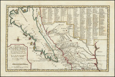
The popular misconception of California as an island can be found on European maps from the sixteenth through the eighteenth centuries. From its first portrayal on a printed map by Diego Gutiérrez, in 1562, California was shown as part of North America by mapmakers, including Gerardus Mercator and Abraham Ortelius. In the 1620s, however, it began to appear as an island in several sources. While most of these show the equivalent of the modern state of California separated from the continent, others, like a manuscript chart by Joao Teixeira Albernaz I (ca. 1632) now in the collection of the National Library of Brasil shows the entire western half of North Americas as an island.
The myth of California as an island was most likely the result of the travel account of Sebastian Vizcaino, who had been sent north up the shore of California in 1602. A Carmelite friar, Fray Antonio de la Ascensión, accompanied him. Ascension described the land as an island and around 1620 sketched maps to that effect. Normally, this information would have been reviewed and locked in the Spanish repository, the Casa de la Contratación. However, the manuscript maps were intercepted in the Atlantic by the Dutch, who took them to Amsterdam where they began to circulate. Ascensión also published descriptions of the insular geography in Juan Torquemada’s Monarquia Indiana (1613) (with the island details curtailed somewhat) and in his own Relación breve of ca. 1620.
The first known maps to show California as an island were on the title pages of Antonio de Herrera’s Descripción de las Indias Occidentales (1622) and Jacob le Maire's Spieghel Der Australische Navigatie (1622). Two early examples of larger maps are those by Abraham Goos (1624) and another by Henry Briggs, which was included in Samuel Purchas’ Hakluytus Posthumus or Purchas his Pilgrimes (1625). In addition to Briggs and Goos, prominent practitioners like Jan Jansson and Nicolas Sanson adopted the new island and the practice became commonplace. John Speed’s map (1626-7), based on Briggs’ work, is well known for being one of the first to depict an insular California.
The island of California became a fixture on mid- and late-seventeenth century maps. The island suggested possible links to the Northwest Passage, with rivers in the North American interior supposedly connecting to the sea between California and the mainland. Furthermore, Francis Drake had landed in northern California on his circumnavigation (1577-80) and an insular California suggested that Spanish power in the area could be questioned.
Not everyone was convinced, however. Father Eusebio Kino, after extensive travels in what is now California, Arizona, and northern Mexico concluded that the island was actually a peninsula and published a map refuting the claim (Paris, 1705). Another skeptic was Guillaume De L’Isle. In 1700, De L’Isle discussed “whether California is an Island or a part of the continent” with J. D. Cassini; the letter was published in 1715. After reviewing all the literature available to him in Paris, De L’Isle concluded that the evidence supporting an insular California was not trustworthy. He also cited more recent explorations by the Jesuits (including Kino) that disproved the island theory. Later, in his map of 1722 (Carte d’Amerique dressee pour l’usage du Roy), De L’Isle would abandon the island theory entirely.
Despite Kino’s and De L’Isle’s work, California as an island remained common on maps until the mid-eighteenth century. De L’Isle’s son-in-law, Philippe Buache, for example, remained an adherent of the island depiction for some time. Another believer was Herman Moll, who reported that California was unequivocally an island, for he had had sailors in his offices that claimed to have circumnavigated it. In the face of such skepticism, the King of Spain, Ferdinand VII, had to issue a decree in 1747 proclaiming California to be a peninsula connected to North America; the geographic chimera, no matter how appealing, was not to be suffered any longer, although a few final maps were printed with the lingering island.
![[World Map with Portraits of Ferdinand Magellan, Willem Schouten, Francis Drake, Thomas Cavendish, Olivier van Noort and Joris van Speilbergen]](https://storage.googleapis.com/raremaps/img/small/90127.jpg)