![Dominia Anglorum in America Septentrionali Specialibus Mappis Londini primum a Mollio… [4 maps--New England; Chesapeake, Georgia, Carolinas & Florida; and Nova Scotia…] By Homann Heirs](https://storage.googleapis.com/raremaps/img/small/60331.jpg)


|
||

|

|
|

|
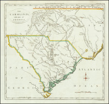
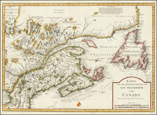
In the mid 18th Century, the Homann Heirs issued this group of four maps on a single sheet, which are based upon earlier maps by Herman Moll, published in London.
Each of the maps were separately issued in Moll's Atlas Minor. The map titles are New Engelland New York New Yersey und Pensilvania; Carolina neksteinem Theil von Florida; Virginia und Maryland; and New Foundland od Terra Nova S. Laurentii Bay…New Schotland.
The Text at the bottom includes notes on the maps and the Iroquois Indians. The maps include the most current information from the British Colonies, including dozens of placenames, Indian Settlements, roads, postal information, etc. The maps also provide details on indigenous battles with the Indians by Col. Barnwell and Col Craven in the Carolina map, details on Indian and English plantations on the Maryland and Virginia map and many other details.
Homann Heirs was a German publishing firm that enjoyed a major place in the European map market throughout the eighteenth century. Founded in 1702 by Johann Baptist Homann, the business passed to his son, Christoph, upon Johann’s death in 1724. Christoph died in 1730, aged only 27, and the firm was inherited by subsequent Homann heirs. This altered the name of the company, which was known as Homann Erben, or Homann heirs. The firm continued in business until 1848.
![(Civil War) Fredericksburg … [with] Map… of the Sioux Expedition [with] Map of the Fight of the 14th A.C. Buzzard Roost, GA [and ] Big Mound [and] Dead Buffalo Lake [and] Dry Fort Creek](https://storage.googleapis.com/raremaps/img/small/97072.jpg)