![[Florida Panhandle to Yucatan] Pas-Kaart Van de Golff van Mexico . . . By Gerard Van Keulen](https://storage.googleapis.com/raremaps/img/small/93130.jpg)


|
||

|

|
|

|
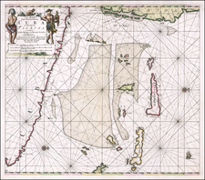
One of the Earliest Obtainable Sea Charts of the Texas, Florida and Gulf Coasts
Rare fourth state of Van Keulen's map of the Gulf Coast, from Florida and Texas to the Yucatan.
Gerard Van Keulen's map of the Gulf Coast is a landmark coastal chart of Texas and the Gulf Coast, extending to just east of Pensacola Bay. Martin & Martin notes that the Van Keulen chart of the Gulf Coast represented the most sophisticated rendering of the Gulf Coast to date. This fourth state continues the process of significantly revising the coastline, especially in Florida, the Gulf Coast and Texas, as demonstrated by a comparison to the earlier states of the map by Johannes Van Keulen:
As can be seen in comparing the two maps, the later editions add dozens of new place names and significantly re-works the coastal details, primarily from information derived from the Spanish. Other than the title, this 4th state bears little resemblance to the earlier editions of the chart.
The map shows dozens of place names along the coast of Texas, Louisiana, Mississippi, Alabama and Florida, along with detailed soundings. Fortifications are shown at Pensacola, F. Anconbazo, Pascagoula, Fort Bilocci (Biloxi), Mexicano (near Cap Delnarte) and several places near the mouth of the Mississippi River, along with Matos de Salvador. The map contains several compass roses, rhumblines, ships at sea and other decorative features.
The Van Keulen family followed the Blaeu family as the official sea chart makers of the Dutch East Indies Company. Their charts are of paramount importance in the development of Marine Cartography. The fourth book of the Van Keulen Zee-fakkel, dedicated to the Americas, is one of most important of all American cartographic works, substantially updating and improving all then existing compilations on the coast of the Americas .
The Van Keulens were a family of chartmakers and publishers. The firm, In de Gekroonde Lootsman (In the Crowned Pilot), was founded in 1678 by Johannes van Keulen (1654-1715). Van Keulen originally registered his business as a vendor of books and instruments (specifically cross-staffs). In 1680, however, he gained a privilege from the States of Holland and West Friesland for the publication of pilot guides and sea atlases.
In that year, van Keulen released his Zee-Atlas (Sea Atlas), which secured him a name in the competitive maritime publishing market. In 1681, he published the first volume of Nieuwe Lichtende Zee-Fakkel (New Shining Sea Torch). This would be the first of an eventual five volumes originally published between 1680 and 1684. A sixth volume was added in 1753. The Zee-Fakel won van Keulen lasting fame. The atlas had charts compiled by Claes Jansz Vooght and artwork from Jan Luyken. It proved immensely popular and was reprinted until 1783. There were translations in French, English, Spanish, and Italian.
The late-seventeenth century was an auspicious time to enter the maritime chart business. Previous industry leaders had either closed shop, died, or retired, leaving space for a new competitor. Van Keulen proceeded to buy up the stock and privileges of several maritime publishing firms; the most notable was the stock of Hendrik Doncker, acquired in 1693.
Johannes’ son, Gerard (1678-1726) took over the business upon his father’s death. Gerard was a skilled engraver and mathematician. His talents were noticed, as in 1706 he was named as Hydrographer to the Dutch East India Company (VOC).
In turn, Gerard’s son Johannes II (1704-1770) came to run the shop. He was also tied to the VOC, and his role as their chartmaker allowed his charts to be considered as quasi-official government documents. It is with access to formerly clandestine VOC geographic knowledge that Johannes the Younger was able to add a sixth volume to the Zee-Fakkel, which covered the East Indies. Johannes also continued to sell instruments, including the recently-invented Hadley’s Quadrant from 1744.
When Johannes II died in 1770, his widow ran the business in his stead, aided by her two sons, Cornelis Buys (1736-1778) and Gerard Hulst (1733-1801). Now a century old, the family business had extended to include an anchor factory. After Cornelis died in 1778, Gerard took on the management of the firm alone. He oversaw the introduction of sextants to their inventory and published the Dutch Nautical Almanac beginning in 1788. Annual editions appeared until 1885. Gerard also served as an original member of the Dutch Commission for Longitude at Sea from 1787.
Gerard’s widow ran the business for nine years after his death, when their son, Johannes Hulst, started to lead the firm in 1810. After his death in 1844, the firm passed out of family hands and into the control of Jacob Swert, a skilled cartographer who had worked for the business for two decades. He passed the work to his son, another Jacob, in 1866. By the mid-nineteenth century, the conversion from sail to steam had diminished the size of the market for charts. Fewer sailors needed fewer maps, charts, and instruments. In 1885, after 207 years in business, In de Gekroonde Lootsman closed its doors and auctioned its stock.
![(Mexican-Aztec Paintings) [Codex Cospi or Bologna] Aglio Mexican Antiquities. Facsimile of an Original Mexican Painting preserved in the Library of the Institute at Bologna, British M[useum]](https://storage.googleapis.com/raremaps/img/small/102339.jpg)
![[Florida & Cuba] Pas Kaart Van De Boght van Florida Met de Canaal Tusschen Florida en Cuba Door Vooght Geometra . . .](https://storage.googleapis.com/raremaps/img/small/48162.jpg)