


|
||

|

|
|

|
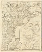
Highly detailed map, showing the region between the Mississippi River and the Atlantic, extending from Virginia to the Great Lakes. This map appeared in the scarce English edition of the American Gazetteer, published in London. The map is based upon Mitchell's seminal map of North America published in 1755, drawing upon Mitchell for the newly revised course of the Ohio and configuration of the Great Lakes, among other features. The map is richly annotated, especially in the Ohio Valley and in the regions of modern day Illinois and Indiana, where no less than 8 separate annotations appear. The map also notes roads, rivers, mountains, lakes, towns, forts, Indian Settlements and a host of other important features. One of the best maps of the region west of the Allegheny Mountains published in English during time. An excellent post-French & Indian War map.
John Gibson flourished in London from 1748 to 1773. He was most likely born ca. 1724. As a young man he was apprenticed to John Blunbell of the Stationers Company, and then to John Pine. He was made free of the Company in 1748. Gibson proved a talented geographer and engraver who produced numerous maps, especially for books and magazines. He worked in collaboration with other map sellers such as Emanuel Bowen and John Roque. His best-known work was the pocket atlas, The Atlas Minimus (1758). Although little is known about his life beyond his publications, he was imprisoned for debt in King’s Bench from May to June of 1765.
![[Revolutionary War Plans of New York, Boston, Charleston, Delaware River to Philadelphia & Havana] Various Plans and Draughts of Cities, Towns, Harbours &c . . .](https://storage.googleapis.com/raremaps/img/small/83450.jpg)

![[ French Louisiana ] Carte De la Louisiane par Le Sr. D'Anville Dressee en Mai 1732. Publiee en 1752](https://storage.googleapis.com/raremaps/img/small/88804.jpg)
![Carte De La Louisiane Et Du Cours Du Mississipi . . . Juin 1718 [1st State!]](https://storage.googleapis.com/raremaps/img/small/59797.jpg)