
![[Southern Africa] Tabula nova partis Africae By Lorenz Fries](https://storage.googleapis.com/raremaps/img/small/103295.jpg)


|
||

|

|
|

|
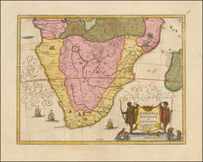
Second Modern Map of Southern Africa—Rare, Early Map From an Early Edition of Ptolemy’s Geographia
Fine map of Southern Africa, one of the earliest obtainable printed maps of the area, from Lorenz Fries’ 1525 edition of Ptolemy’s Geographia.
The second earliest map of the region, it is based on one of the modern maps first added to Ptolemy’s ancient maps in Martin Waldseemüller’s 1513 edition of the Geographia. Fries redrew and re-engraved the Waldseemüller maps at a reduced scale for his own Ptolemy.
The present map shows all of Southern Africa below the Equator. The entire width of the continent is depicted, with the Atlantic Ocean to the west and the island of São Tomé and Príncipe (S. Thome) in the upper left-hand corner. The Indian Ocean (Sinus Barbaricus, Mare Prassodum) bounds the map to the east. A thick line representing the Tropic of Capricorn cuts through the lower part of the continent. The island of Madagascar, discovered by the Portuguese in 1500, can be seen in the lower right-hand corner, farther south than in actuality.
Both the east and west coasts are crowded with place names, reflecting information available to sixteenth-century mapmakers like Fries thanks to Portuguese exploration. In contrast, the interior of the continent contains few place names, as little was known about its actual geography at that time. Indeed, few Europeans would travel beyond the coastal regions until the mid-nineteenth century.
Where Waldseemüller left the interior largely empty in his earlier version of the present map, Fries inserts hills and rivers, as well as important geographical hypotheses and mythical elements like the Mountains of the Moon. Near the center of the map, next to a steep mountain range, Fries depicts the basilisk (Basilicus), a winged reptile that, according to Pliny the Elder, could kill by breath or glance. The basilisk’s crown designates it king of the serpents.
Near the basilisk, Fries adds a lake, Saphat lacus, which is the source of three rivers. This feature would later be adopted by Mercator.
Fries’ Geographia was first printed by Johann Grüninger in 1522, but that edition of the work is very rare and for the most part unobtainable. In 1525, an improved edition, from which the present map originates, was issued. This edition featured a re-edit of the text by Willibald Pirkheimer, from the notes of Regiomontanus (Johannes Müller von Königsberg). Fries based his work on Martin Waldseemüller’s edition of 1513 of the Geographia Opus Novissima, printed by Johann Schott, redrawing and re-engraving the maps at a reduced scale.
The Mountains of the Moon
The present map contains several elements that would appear odd to the modern eye. The Mountains of the Moon (Mone Lune), depicted at center below the Equator, were believed for centuries to be the source of the Nile River. Ptolemy’s Geographia tells the story Diogenes, a Greek trader and merchant traveling in East Africa around 110 AD. Diogenes supposedly discovered the Mountains of the Moon, whose snowmelt fed two great lakes, which in turn fed the Nile. While this map shows a second-century legend, the story was still a viable geographic theory in the sixteenth century. The Mountains of the Moon remained on maps long into the eighteenth century and beyond.
Rulers, Real and Imaginary
The present map depicts four different rulers. Near the Equator to the east, a crowned, bearded ruler is labled Quiola Regnum, likely referring to the area of Quiloa, now known as Kilwa Kisiwani, Tanzania. Kilwa Kisiwani was a major Swahili trading city that controlled Indian Ocean trade with Arabia, India, and China, especially between the thirteenth and sixteenth centuries, when Kilwa Kisiwani merchants traded gold and ivory for silver, perfumes, and Chinese porcelain. The city even minted its own currency between the eleventh and fourteenth centuries. After the Portuguese established a fort on Kilwa Kisiwani in the sixteenth century, the city began to decline.
Farther south near Mozambique (Moncabiqui), a crowned, bare-chested ruler is labeled Charagassa. Above the Tropic of Capricorn sits a third king, with robe and scepter, Hengi Zedaici.
Off the southeast coast, Emmanual, the most Christian King of Portugal (Manual I the Great and Fortunate, r. 1495-1521) sits astride a sea monster. This last scene is taken directly from Waldseemüller’s Carta Marina (1516).
Ptolemy’s Geographia in Renaissance Europe
The translation of Claudius Ptolemy’s Geographia from Greek into Latin for the first time in the late fourteenth and early fifteenth centuries spurred a wave of renewed interest and updated editions.
Ptolemy’s ideas had been absent from western European intellectual history for roughly a thousand years, although Arab scholars interacted with his ideas from the ninth century onward. In 1295, a Greek monk found a copy of Ptolemy in Constantinople; the emperor ordered a copy made and the Greek text began to circulate in eastern Europe. In 1393, a Byzantine diplomat brought a copy of the Geographia to Italy, where it was translated into Latin in 1406 and called the Cosmographia. The manuscript maps were first recorded in 1415. These manuscripts, of which there are over eighty extant today, are the descendants of Ptolemy’s work and a now-lost atlas consisting of a world map and 26 regional maps.
When Ptolemy’s work was re-introduced to Western scholarship, it proved radically influential for the understanding and appearance of maps. Ptolemy’s use of mathematics and astronomy to depict the world appealed to the intellectual climate of the Renaissance. Ptolemy employs the concept of a graticule, uses latitude and longitude, and orients his maps to the north—concepts we take for granted today.
The Geographia’s text is concerned with three main issues with regard to geography: the size and shape of the earth; map projection, i.e. how to represent the world’s curve proportionally on a plane surface; and the corruption of spatial data as it transfers from source to source. The text also contains instructions as to how to map the world on a globe or a plane surface, complete with the only set of geographic coordinates (8000 toponyms, 6400 with coordinates) to survive from the classical world.
Early printed editions of Ptolemy’s Geographia
Some of the most important, and the most numerous, early printed maps were in editions of Ptolemy’s Geographia (Cosmographia). From 1475 to 1650, there were more than forty new editions of the Geographia, which increasingly featured updates based on current knowledge, including recent voyages of discovery.
The text was first published in 1475 in Venice without the maps. An edition with the maps followed in 1477, printed in Bologna. These maps were another first—they were the first copperplate maps, in which an engraver scores copper, which is then inked and pressed. The Bologna edition included 25 of the original 26 regional maps (map XV was missing), as well as the world map.
A second edition with maps appeared in Rome in 1478. The third edition with maps was printed in Florence in 1482, the first to be printed in a vernacular language, Italian. It included 31 copperplate engraved maps, making it the first to augment the traditional 27 Ptolemaic maps with tabulae novellae, or modern maps. The modern maps included maps of Italy, Spain, and France.
The next edition to include the maps was the 1482 Ulm edition, which was the first atlas to be printed north of the Alps, as well as the first edition to use woodcut, not copperplate, printing. Copperplate engraving is an intaglio method; it cuts into the surface of the printing plane in order to create an impression when the engraved lines are inked. Woodcut engraving is a relief method; the surfaces to be inked are left standing, while the blank spaces are cut away.
Martin Waldseemüller separated his 1513 edition into two sections—one with the original maps and text, and the second with updates based on current knowledge of the world, including twenty modern maps. Fries’ followed this trend in his 1522 and 1525 editions, separating Ptolemy’s respected work from new knowledge and updated maps. He also added three more modern maps than Waldseemüller, but based on the other mapmaker’s work, for a total of 23.
This is one of these modern maps, a testament to the importance of Ptolemy to early modern geography, but also to the ingenuity of that time. It is the early obtainable map of this region and one of the earliest maps to show the region in detail.
Lorenz (Laurent) Fries (ca. 1485-1532) was born in Mulhouse, Alsace. He studied medicine, apparently spending time at the universities of Pavia, Piacenza, Montpellier and Vienna. After completing his education, Fries worked as a physician in several places before settling in Strasbourg in about 1519. While in Strasbourg, Fries met the Strasbourg printer and publisher Johann Grüninger, an associate of the St. Dié group of scholars formed by, among others, Walter Lud, Matthias Ringmann and Martin Waldseemüller.
From 1520 to 1525, Fries worked with Grüninger as a cartographic editor, exploiting the corpus of material that Waldseemüller had created. Fries' first venture into mapmaking was in 1520, when he executed a reduction of Martin Waldseemüller's wall map of the world, first published in 1507. While it would appear that Fries was the editor of the map, credit is actually given in the title to Peter Apian. The map, Tipus Orbis Universalis Iuxta Ptolomei Cosmographi Traditionem Et Americ Vespucii Aliorque Lustrationes A Petro Apiano Leysnico Elucubrat. An.o Dni MDXX, was issued in Caius Julius Solinus' Enarrationes, edited by Camers, and published in Vienna in 1520.
Fries’ next project was a new edition of the Geographia of Claudius Ptolemy, which was published by Johann Grüninger in 1522. Fries evidently edited the maps, in most cases simply producing a reduction of the equivalent map from Waldseemüller's 1513 edition of the Geographie Opus Novissima, printed by Johann Schott. Fries also prepared three new maps for the Geographia, of Southeast Asia and the East Indies, China, and the world, but the geography of these derives from Waldseemüller's world map of 1507.
The 1522 edition of Fries' work is very rare, suggesting that the work was not commercially successful. In 1525, an improved edition was issued, with a re-edit of the text by Willibald Pirkheimer, from the notes of Regiomontanus (Johannes Müller von Königsberg).
After Grüninger's death in ca. 1531, the business was continued by his son Christoph, who seems to have sold the materials for the Ptolemy to two Lyon publishers, the brothers Melchior and Gaspar Trechsel, who published a joint edition in 1535, before Gaspar Trechsel published an edition in his own right in 1541.
![[Cape Town] Africa S.W. Coast Table Bay surveyed by Captn. Sir Edwd. Belcher C.B. 1846.](https://storage.googleapis.com/raremaps/img/small/78202.jpg)
![[South Africa / Namibia / Angola] Coste Occidentale D'Afrique Depuis le XIe. Degre De Latitude Meridional, Jusqua'au Cap de Bonne Esperance Tiree de la Carte de l'Ocean Meridional . . . 1739](https://storage.googleapis.com/raremaps/img/small/77033.jpg)