|
||

|

|
|

|
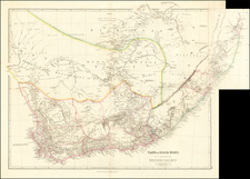
The Admiralty Survey of Table Bay and Cape Town
Rare and early harbor chart of Table Bay, with an important town plan of the area around Cape Town.
The area was surveyed by the British Admiralty in 1846, engraved by J. & C. Walker, and sold by authorized chart dealer R. B. Bate.
The chart includes numerous soundings in Table Bay from systematic grid surveys and running surveys. These are augmented by fathom lines that indicate the deepening of the harbor. A simple compass rose allows for the easy plotting of courses on a set bearing. As this is a high-resolution harbor chart, rather than a grid of latitude and longitude there are two astronomically-derived positions given, for the southeast bastion of the Amsterdam Battery and, farther inland, the Royal Observatory.
Notably, this chart also includes a detailed plan of Cape Town, including the Parade, with its Library and Commercial Rooms, the Castle, Fort Knockle, and the Royal Observatory. The road to the observatory is still unfinished. The chart also includes a fine treatment of the topographical features to the north of Cape Town, including the Lion’s Rump.
This chart is the result of the Admiralty’s modern survey of the area around the Cape of Good Hope, which began in 1840. It built on the work undertaken by Captain William Fitzwilliam Owen between 1822 and 1826. Previous, partial surveys were completed with less precise instruments and without adequate support, meaning that even the best privately-available charts by Arrowsmith, Wyld, and others were not sufficient for navigation. The present chart was based on the survey of 1846 by Sir Edward Belcher, captain of the H.M.S. Samarang, who had recently completed one of the earliest chartings of the waters around Hong Kong.
The British in the Cape
The Cape had been occupied by Europeans since 1652, when the Dutch East India Company established a refreshment post there. During the Napoleonic Wars, both France and Britain attempted to take the strategic colony; the British succeeded in 1795. They then returned the colony to the Dutch in 1802, but took it again in 1806. It was permanently ceded to Britain in the Anglo-Dutch Treaty of 1814.
Vitally located on the route from the Atlantic to the Indian Oceans, it was an important base before the opening of the Suez Canal in 1869. Many more British settlers came after 1820, and Boer settlers migrated north in the 1830s, part of the Great Trek, putting more strain on land and raising tension levels with Indigenous groups. Local peoples were made to work in the colony, beginning the pass law system that would become notorious in the twentieth century.
The Cape Colony was granted its own parliament in 1854 and their own Prime Minister in 1872. In 1910, the Cape Colony was consolidated with the Boer Republics, following their victory in the Boer Wars. Cape Town was named the capital of this Union of South Africa and the later Republic of South Africa.
Sir Edward Belcher
This chart was surveyed by one of the most notable surveyors in the Royal Navy in the nineteenth century. Belcher was born in Nova Scotia in 1799. His merchant father moved the family to Surrey in 1811. Young Edward joined the navy in 1812, serving in the English Channel and on the Newfoundland station. He was a midshipman on HMS Superb at the bombardment of Algiers in 1816.
Belcher made lieutenant in 1818. His surveying career began with his appointment as assistant surveyor in HMS Blossom, which sailed for the Bering Strait in 1825. He spent three years in the Pacific. Upon his return, in 1829, Belcher was promoted to commander and he led the HMS Aetna from 1830 to 1833, and in which he surveyed the coasts of west and north Africa. He then served on the home survey in the Irish Sea before being appointed to HMS Sulphur, which spent three years on the west coasts of North and South America.
He arrived at Singapore in 1840, when he was ordered to China as part of the First Opium War. In 1841, Belcher led one of the first surveys of the waters near Hong Kong. Belcher returned the Sulphur to England in 1842, after seven years away. During this cruise, Belcher was promoted to post rank and awarded a CB and a knighthood. He also published an account of his circumnavigation in 1843.
The now celebrated Belcher was given command of HMS Samarang, from which he was to survey the coast of China, now open to British trade. He was diverted to Borneo, the Philippines, and Taiwan, where he surveyed and fought pirates. En route back to England, he surveyed near the Cape of Good Hope as well. Back in England again by 1847, he published another voyage account the following year.
In 1852, Belcher was commanded to join the search for Sir John Franklin. This proved to be a mistake for Belcher, as his abilities as a survey commander did not translate well to the demands of the largest Arctic voyage to date. Belcher was given a squadron of five ships—HMS Assistance, HMS Resolute, HMS North Star, Pioneer, and Intrepid.
Belcher quickly became nervous about his men and ships. He ordered four of the five ships abandoned (all but the North Star) and returned to England in October 1854 with Phoenix and the Breadalbane, who had come to assist them. Upon his return, Belcher was court martialed for the loss of the ships and never received another command. He did, however, publish another account of his time at sea, this time bombastically titled The Last of the Arctic Voyages (1855).
While no longer in active command, Belcher did reach flag rank by seniority in 1861, vice admiral in 1866, and admiral in 1872. He was made a KCB in 1867. In retirement, Belcher turned to writing. He died in 1877.
Rarity
OCLC locates only one example of the chart, in the British Library.
We note that Susanna Fisher offered an example of the chart in map dealer catalogs between 1989 and 1992 for about $700.
The British Admiralty has produced nautical charts since 1795 under the auspices of the United Kingdom Hydrographic Office (HO). Its main task was to provide the Royal Navy with navigational products and service, but since 1821 it has also sold charts to the public.
In 1795, King George III appointed Alexander Dalrymple, a pedantic geographer, to consolidate, catalogue, and improve the Royal Navy’s charts. He produced the first chart as the Hydrographer to the Admiralty in 1802. Dalrymple, known for his sticky personality, served until his death in 1808, when he was succeeded by Captain Thomas Hurd. The HO has been run by naval officers ever since.
Hurd professionalized the office and increased its efficiency. He was succeeded by the Arctic explorer Captain William Parry in 1823. By 1825, the HO was offering over seven hundred charts and views for sale. Under Parry, the HO also began to participate in exploratory expeditions. The first was a joint French-Spanish-British trip to the South Atlantic, a voyage organized in part by the Royal Society of London.
In 1829, Rear-Admiral Sir Francis Beaufort was appointed Hydrographer Royal. Under his management, the HO introduced the wind force scale named for him, as well as began issuing official tide tables (1833). It was under Beaufort that HMS Beagle completed several surveying missions, including its most famous voyage commanded by Captain FitzRoy with Charles Darwin onboard. When Beaufort retired in 1855, the HO had nearly two thousand charts in its catalog.
Later in the nineteenth century, the HO supported the Challenger expedition, which is credited with helping to found the discipline of oceanography. The HO participated in the International Meridian Conference which decided on the Greenwich Meridian as the Prime Meridian. Regulation and standardization of oceanic and navigational measures continued into the twentieth century, with the HO participating at the first International Hydrographic Organization meeting in 1921.
During World War II, the HO chart making facility moved to Taunton, the first purpose-built building it ever inhabited. In 1953, the first purpose-built survey ship went to sea, the HMS Vidal. Today, there is an entire class of survey vessels that make up the Royal Navy’s Hydrographic Squadron. The HO began to computerize their charts in the late 1960s and early 1970s. In 1968, the compilation staff also came to Taunton, and the HO continues to work from there today.
![Egypt and Barca [with] Abissina and Nubia [with] Congo. Angola. Cafres. Monoemugi. Monomotapa. Zanguebar & Madagascar](https://storage.googleapis.com/raremaps/img/small/78890.jpg)