|
||

|

|
|

|
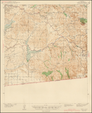
The Map That Put Mammoth Lakes On The Map -- Including Glaciers!
Highly detailed of the area aound Mammoth Lakes, California, in Mono County.
The map is exceptionally detailed, with roads, mountains, lakes, rivers, some hunting, fishing and hiking information and other details. At the top left and top right, inset maps show the broader area (left) and part of California (right), both centered on Mammoth Lakes.
Perhaps most notable is the location of Glaciers in the area, including the Lyell Glacier.
The present map is Emmet Hayden's first map.
The Hayden Map Co. promotion notes that they will soon complete maps of all the fishing and resort recreational areas within the 9 western states.
The Hayden Map Company was founded in the 1930s by Emmet Hayden. In 1927, Emmet Hayden procured a lease in the Inyo National Forest, where he built a four bedroom log cabin which is the Mammoth Lakes Museum today. Emmet was an Engineer, Surveyor, and Mapmaker by training. He put Mammoth Lakes on his 1934 map, titled "A Circle of Enchantment." Originally, the Hayden Map Company did sub-division work in the Los Angeles area. After moving to Mammoth Lakes for his summer residence, he had the idea of being a hunting and fishing guide, which became the Hayden Map Company. Hayden's two earliest maps were the "Three Flags Highway" and "The Circle of Enchantment."
The map is rare on the market. OCLC locates only the copy at UCLA.
![[ San Francisco Bay, North Coast & Monterey Bay Region ] Amer. Sep. No. 46 Nouvelle Californie](https://storage.googleapis.com/raremaps/img/small/98751.jpg)
![[Austins Colony] Mexico & Guatemala](https://storage.googleapis.com/raremaps/img/small/94054.jpg)