|
||

|

|
|

|
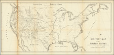
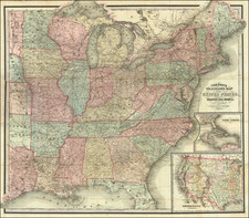
Rare teaching map of the history of the United States, advertised for sale by Bacon in 1899.
The map was part of Bacon's Excelsior School-Map series and specifically the "Excelsior Wall-Atlases For Secondary Schools"
The present set of 5 maps on a single sheet shows the history of the United States.
The top map shows the United States, colored based on the various acquisitions of territory which led to its then current configuraiton, along with historical dates, such as the first settlements in each region, dates of discovery and exploration, etc.
The second map illustrates Toscanelli's Map of 1474, the map drawn from the Behaim globe and utilized by Columbus on his first voyage, with the actual location of America superimposed over the Toscanelli map, to illustrate where Columbus thought he had gone and where he actually went.
The Third map illustrates the US at the time of the French & Indian War, illustrating the major regions and colonial powers which controlled each area, with th Pacific Northwest shown as "Conflicting Claims".
The Fourth map illustrates Growth and Development of the States of the North-west out of the Territory Acquired From France By Conquest.
The Fifth map shows the Civil War.
Bacon's map is apparently quite rare today. We locate no other examples.