


|
||

|

|
|

|
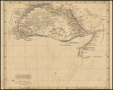
Detailed map of the Central portion of Africa, showing the route taken in Henry Stanley's mission to rescue the Emin Pasha expedition along the Congo River and across the Congo Free State between the Atlantic and Indian Oceans.
The map highlights the partially explored lands of Central Africa, including the Congo rain Forest, the large lakes of Africa's Rift Valley, and some of the newly discovered mountain ranges. The red line running across the map depicts the route of the famous African explorer Henry Morton Stanley, who mounted a rescue mission to extract Emin Pasha, the governor or bey of Equatoria, from the middle of an Arab revolt.
The Emin Pasha Relief Expedition of 1886 to 1889, was one of the last major European expeditions into the interior of Africa in the nineteenth century, ostensibly to the relief of Emin Pasha, General Charles Gordon's besieged governor of Equatoria, threatened by Mahdist forces. The expedition was led by Henry Morton Stanley and came to be both celebrated for its ambition in crossing "darkest Africa", and notorious for the deaths of so many of its members and the disease unwittingly left in its wake.
The map shows boundary of free trade area in the south.
![Fessae, et Marocchi Regna Africae Celeberr. describebat Abrah. Ortelius. 1595 [with large inset of West Africa]](https://storage.googleapis.com/raremaps/img/small/95634.jpg)