|
||

|

|
|

|
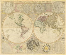
Engraved by Dutch Master Romeyn De Hooghe!
Fine old color example of the first state of Frederick De Wit's richly embellished map of the World, first published in 1668.
Australia is shown with the discoveries made by Tasman, on his first and second voyages 1642-44. The VOC, in having sent Tasman on two voyages, not only to chart the South Land but importantly to make contact with the natives and to engage in trade, were disappointed with the lack of trading opportunities present in the barren and inhospitable land. Consequently, the VOC lost interest in further charting of the Australian continent other than for the updating of existing charts for navigational purposes. The post-Tasman shape of Australia depicted on maps, was to remain unchanged until James Cook's discovery and charting of the east coast, in 1770.
Only a single New Zealand Coastline is shown, again based upon Tasman.
California appears as an island, with no northwest coast of America shown. An early configuration of the Great Lakes is given, with two of the lakes open to the west.
The map is embellished by four large lively allegorical scenes, representeing the four elements. Fire is shown by war and destruction, air by the heavens, earth by harvesting and husbandry, and water by ships and a spouting whale. There are groups of figures between the hemisperheres and on either side of the smaller polar maps.
The present map is a prototype for a number of other mapmakers, and would be copied by Justus Danckerts, David Funcke, Joachim Bormeester, Gerrit van Schagen, Louis Renard, R & J Ottens, Gerard Hulst Van Keulen over the course of the next 140 years (up to 1802!).
De Wit (1629 ca.-1706) was a mapmaker and mapseller who was born in Gouda but who worked and died in Amsterdam. He moved to the city in 1648, where he opened a printing operation under the name of The Three Crabs; later, he changed the name of his shop to The White Chart. From the 1660s onward, he published atlases with a variety of maps; he is best known for these atlases and his Dutch town maps. After Frederik’s death in 1706, his wife Maria ran the shop for four years before selling it. Their son, Franciscus, was a stockfish merchant and had no interest in the map shop. At the auction to liquidate the de Wit stock, most of the plates went to Pieter Mortier, whose firm eventually became Covens & Mortier, one of the biggest cartography houses of the eighteenth century.
![The Western Hemisphere... [with:] The Eastern Hemisphere A Stereographical Projection on the Twentieth Meridian](https://storage.googleapis.com/raremaps/img/small/97573.jpg)