
This item has been sold, but you can enter your email address to be notified if another example becomes available.


|
||

|

|
|

|
Stock# 47719
Description
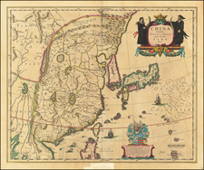
Detailed map of Hong Kong Island and territory north to the Sham Chun River.
The Canton Railroad is illustrated, as are the built up areas on both sides of Victoria Harbor.
Britain secured the New Leased Territories in 1898 as an extension of Kowloon. The primary motive in expanding the holdings was to counter the encroachment of the other European powers, including France in southern China, and the Russians at Port Arthur.
Shows rivers, mountains and villages in the New Territories. The main roads and railway are also shown. The village of Sham Chun is shown just over the Frontier.
Condition Description
Small area of loss north of "Lan Tau" replaced with facsimile, barely affecting printed image. Overall light soiling, mostly confined to margins.
![[Map of Western Shangdong Province]](https://storage.googleapis.com/raremaps/img/small/60891.jpg)