|
||

|

|
|

|
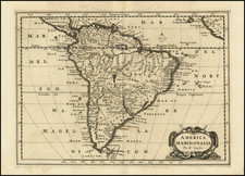
A fascinating early 19th Century reissue by the French firm of Chez Jean of the 1787 Clouet, revised to include the first voyage of Captain Cook.
Gone is the Bay of the West, although the Northwest Coast still hints at some sort of inland sea. The newly formed US is noted and shown to include Florida, with a huge Louisiana Territory.
The routes of Cook and many other discoverers are shown in the Atlantic and Pacific. A slightly more up-to-date inset map focuses on northern North America and the explorations of Cook, Clark and the Russians. In this map, a strait exists between Siberia and North America, Greenland is part of the mainland, and the existence of the United States is recognized.
The highly decorative title cartouche is also a throwback, featuring America riding a particularly fierce alligator and gazing upon a cornucopia.
Jean-Baptiste Nolin (ca. 1657-1708) was a French engraver who worked at the turn of the eighteenth century. Initially trained by Francois de Poilly, his artistic skills caught the eye of Vincenzo Coronelli when the latter was working in France. Coronelli encouraged the young Nolin to engrave his own maps, which he began to do.
Whereas Nolin was a skilled engraver, he was not an original geographer. He also had a flair for business, adopting monikers like the Geographer to the Duke of Orelans and Engerver to King XIV. He, like many of his contemporaries, borrowed liberally from existing maps. In Nolin’s case, he depended especially on the works of Coronelli and Jean-Nicholas de Tralage, the Sieur de Tillemon. This practice eventually caught Nolin in one of the largest geography scandals of the eighteenth century.
In 1700, Nolin published a large world map which was seen by Claude Delisle, father of the premier mapmaker of his age, Guillaume Delisle. Claude recognized Nolin’s map as being based in part on his son’s work. Guillaume had been working on a manuscript globe for Louis Boucherat, the chancellor of France, with exclusive information about the shape of California and the mouth of the Mississippi River. This information was printed on Nolin’s map. The court ruled in the Delisles’ favor after six years. Nolin had to stop producing that map, but he continued to make others.
Calling Nolin a plagiarist is unfair, as he was engaged in a practice that practically every geographer adopted at the time. Sources were few and copyright laws weak or nonexistent. Nolin’s maps are engraved with considerable skill and are aesthetically engaging.
Nolin’s son, also Jean-Baptiste (1686-1762), continued his father’s business.
![[ Sea of the West ] L'Amerique divisee en ses principaux Etats . . .](https://storage.googleapis.com/raremaps/img/small/103460.jpg)