


|
||

|

|
|

|
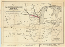
First edition of this Mississippi River Rarity.
The map extends from Minneapolis to the confluence of the Mississippi and Illinois Rivers.
The map is the work reflects the 10 years of surveys and explorations of the River, although the primary survey work was completed between 1878 and 1879, as noted in the title. The work would later be re-issued in 1903-1905 on the same scale, with significant additions and changes.
Howard Nixon Elmer was Civil Engineer who spent much of his professional life surveying and undertaking engineering projects on the Mississippi River.
The 1887 edition of Biographical Record of the Officers and Graduates of the Rensselaer Polytechnic Institute at page 475 identifies Howard Nixon Rice as follows:
Howard Nixon Elmer, C. E., son of David Potter and Mary E. (Nixon) Elmer, was born in Bridgeton, Cumberland county, New Jersey, April 27th, 1856. Lived at Bridgeton and attended the West Jersey Academy until 1872, when he spent one year at Genesee Academy, Genesee, N. Y. Entered the Institute September, 1873. Entered upon the work of his profession July, 1878, as second assistant on United States survey of Mississippi frem St. Paul to Lansing, Iowa. At Park Island, Ill., during the winter of 1878 and 1879.
June, 1879, in charge of improvements at Smiths Bar, Mississippi River; March, 1880, engineer Grand Tower mining manufacturing company, Grand Tower, Ill.; July, 1880. first assistant engineer on survey for reservoir at headwaters of Mississippi River, at St. Paul, Minn. Summer of 1881, preliminary surveys for St. Paul water works, and improvement of water power, Little Falls, Minn.; March, 1882, entered the firm of Elmer & Newell, civil engineers and contractors, St. Paul, Minn. In July, 1883, made surveys and examinations for sewerage of Duluth, Minn. Designed and built dams for improvement of navigation in the Mississippi river at Smiths Bar, Wis. Inspector of buildings and sanitary matters pertaining thereto, for St. Paul, Minn.
Member American Association for the advancement of Science, Engineers Club of Philadelphia, Pa., and Civil Engineers Society, of St. Paul, Minn. P. O. address, P. O. Box 276, St. Paul, Minn.
The full title is:
Map of the Mississippi River from the Falls of St. Anthony to the junction of the Illinois River.compiled from survey of upper Mississippi River from St. Paul to Grafton, made in 1878 and 1879 under direction of F.U. Farquhar.with additions from notes and surveys under direction of G.K. Warren.J.N. Macomb.and A. Mackenzie, Corps of Engr's, drawn under the direction of Major A. Mackenzie, Corps of Engr's. U.S.A. by H. Bosse and A.J. Stibott. 1887-1888.
Rarity
The map is quite rare on the market. We note no examples at auction or in dealer catalogs dating back more than 30 years.
![[ Michigan & 3 Great Lakes ] Amer. Sep. No. 42 Haut Canada Et Michigan](https://storage.googleapis.com/raremaps/img/small/98409.jpg)


![[ Northern Pacific Railroad ] NEW 7-30 GOLD LOAN OF THE Northern Pacific Railroad Co. SECURED BY FIRST MORTGAGE ON RAILROAD AND LAND GRANT. SAFE! PROFITABLE! PERMANENT!](https://storage.googleapis.com/raremaps/img/small/101828.jpg)