|
||

|

|
|

|
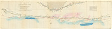
Fine example of the second state (L°6°) of Robert Dudley's chart of the coast of Southwestern Africa, the earliest obtainable sea chart of the region.
The map shows the coastline of Namibia and Angola, with the Tropic of Capricorn running through the map.
As noted by Parry in Printing & The Mind of Man, "In the genre of sea charts it is Sir Robert Dudley (1573-1649) who made the greatest impression among the English cartographers of the seventeenth century, particularly in his charting of the East Indian archipelago . . . the first atlas to contain detailed charts of the whole East Indian and Philippine archipelagoes."
According to Suarez, Dudley's interest in the Far East began in his youth, and he backed Benjamin Wood's 1596 expedition to Southeast Asia which ended in a shipwreck on the Burmese coast. "A man of enormous talents, ranging from adventurer and explorer to scientist, mathematician, naval architect, navigator and cartographer," Dudley was the illegitimate son of the Earl of Leicester, the favorite of Elizabeth I and brother-in-law to Thomas Cavendish. In 1594 Dudley sailed with Sir Francis Drake to Guiana and Trinidad in search of El Dorado and two years later received a knighthood for his part in the Earl of Essex's raid on Cadiz.
Dudley eventually settled in Florence and in a naval capacity entered the service of the Grand Dukes of Tuscany. Dudley's Arcano del Mare was the first nautical atlas published by an Englishman and one of the most ambitious and beautiful cartographic works ever produced. The plates were engraved by Antonio Lucini, who claimed that twelve years and 5,000 pounds of copper were expended in the preparation of the plates. The resulting charts are among the most distinctive productions of early cartography.
Robert Dudley (1574-1649) is one of the most intriguing historical figures of the late Elizabethan period. His father, also named Robert and the first Earl of Leicester, was a favorite of Elizabeth I’s. The Earl was a supporter of exploratory expeditions and backed Francis Drake on his circumnavigation (1577-1580) and Martin Frobisher on his 1576 voyage to find the Northwest Passage. Robert the Younger was the illegitimate son of the Earl and Lady Douglas Sheffield, born in 1574.
Dudley attended Christ Church, Oxford, starting in 1587. A year later, at only 14, Dudley stood by his father at Tilbury, witnessing Queen Elizabeth’s famous speech in preparation for resisting the Spanish Armada. His father died in September that year, giving Robert a sizeable inheritance. In 1594, Dudley led an expedition to Guiana, where some of his men explored up the Orinoco River in search of gold. In 1596, Dudley joined an expedition against Cadiz.
All these experiences left Dudley in favor, and he thought the time was right to establish his legitimacy. In court proceedings from 1603 to 1605, Dudley fought for his right to his father’s titles, but the Star Chamber ruled against him and he had to leave England for self-exile in Italy. He settled in Florence, where he designed and built ships and advised Ferdinand I, Grand Duke of Tuscany.
While in Florence, Dudley also compiled all his sailing notes and thoughts on navigation (and those of others including, purportedly, Francis Drake, with whom he sailed in 1596, and Thomas Cavendish, to whom he was related by marriage) into a work called Arcano del Mare, or The Secret of the Sea. He finished the manuscript of the work in 1636 and published the work himself, at age 73, a decade later in 1646-7.
Dudley’s Arcano del Mare (Mystery of the Sea) is one of the most important atlases ever produced and one of the most complex. It is the first sea-atlas of the whole world; the first with all the charts constructed using Mercator's new projection, as corrected by Edward Wright; the first to give magnetic declination; the first to give prevailing winds and currents; the first to expound the advantages of Great Circle Sailing; and the first sea-atlas to be compiled by an Englishman, albeit abroad in Italy. Dudley broke completely with the contemporary style of charts. He showed lines of latitude and longitude and omitted all compass lines. In doing so, his purpose was more intellectual than practical: techniques for determining longitude at sea were not refined until more than two centuries later. The maps are by English and other pilots and it is generally accepted that the work was both scientific and accurate for the time. Dudley used the original charts of Henry Hudson, and for the Pacific Coast of America used Cavendish's observations. The Arcano del Mare was a monumental and totally original task; the charts, representations of instruments, and diagrams all engraved on huge quantities of copper over many years with an exactitude incorporating the minutest detail and printed on the best possible paper.
Antonio Francesco Lucini, the engraver, was born in Florence c. 1610. Before being employed by Dudley, he had already engraved views of Florence and scenes of the Turkish Wars. In a printed introductory leaf found in one copy in the British Library, Lucini states that he worked on the plates in seclusion for twelve years in a Tuscan village, using no less than 5,000 lbs (2,268 kg) of copper.
![(South Africa) Coutumes Moeurs & Habillemens des Peuples Qui Habitent aux Environs du Cap de Bonne Esperance avec une Description des Animaux et Reptiles qui set truvent dans ce Pais [Customs, Manners, and Attire of the Peoples Who Inhabit the Vicinity of the Cape of Good Hope, with a Description of the Animals and Reptiles Found in this Country.]](https://storage.googleapis.com/raremaps/img/small/89738.jpg)
![[South African Republic, Orange Free State, Natal, Basutoland, etc.] The Absent-Minded Beggar](https://storage.googleapis.com/raremaps/img/small/78441.jpg)