|
||

|

|
|

|
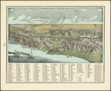
Striking and beautifully illustrated map of the Holy Land, published by the German Association of the Holy Land shortly after the conclusion of WWII.
The map provides a very lively and idiosyncratic depiction of the region. Most notably, the extensive use of green and depiction of farning and agricultural uses of the land make the region look very inviting, at a time when the exodus of German Jews to Palestine was likely quite high, although maker of the map was perhaps more concerned with the relations between German and Palestinian Christians.
Verein vom Heiligen Lande
Established 1855 by the German Catholic Bishops, the German Association of the Holy Land (DVHL) is a relief organization for the Christians in the Middle East. Besides the support of needy people, the Association considers education and the promotion of interreligious dialogue and reconciliation to be a main part of its mission. The Association also regularly organizes pilgrimages to the Holy Land and sends volunteers from Germany to different social and educational institutions in the Holy Land.
The combination of national enthusiasm and religious sense of mission saw organization grow to 30,000 members. In competition with other European nations and denominations of the club erected large magnificent buildings in Jerusalem .
![[Holy Land] Terra Sancta XXIII. Nova Tabula](https://storage.googleapis.com/raremaps/img/small/100585.jpg)