|
||

|

|
|

|
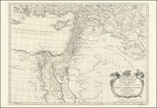
Finely colored example of this striking map of the Holy Land, published by Robert Seaton.
The title to the map credits the surveys of French General Jean-Baptiste Kléber as the primary source of the map, referencing Kléber's time as commander of the French forces in Egypt during the Napoleon's Egyptian Campaign.
This is a later edition of a map first issued in 1828. There are many places names on this map which do not appear on the first edition, particularly in the Sinai Peninsula. The first edition also did not include the vignettes of Cairo and the Pyramids which appear at the bottom of this issue.
A note at the bottom right, which also does not appear on the first edition, states
“Independent of the sacred writings, the ancient authorities consulted in the compilation of the Map are Pliny, Herodotus, Strabo and Josephus, the modern D’Anville, ,,, Burckhardt, Drs. Shaw & Clarke, to this information is added the personal Surveys of Egypt by the Proprietor, in 1850, & the recent American Surveys.”
The border contains small heraldic devices for European countries and ecclesiastical offices. At the top center is an elaborate image of the British Coat Arms flanked by a lion and unicorn, surrounded by symbols of Britain's military strength.
Includes plans of Jerusalem and the Temple below the title which also appear in the first edition.