|
||

|

|
|

|
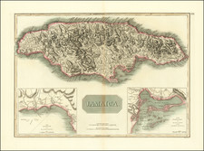
One of the Rarest Jamaican Maps of the 18th Century
Rare map of Jamaica, which appeared in Thomas Jefferys', A general topography of North America and the West Indies. Being a collection of all the maps, charts, plans, and particular surveys, that have been published of that part of the world, either in Europe or America, published by Robert Sayer in 1768.
Intended initially as a compilation of all of Jefferys separately published American maps, the General topography of North America and the West Indies, is of the utmost rarity, as are the vast majority of maps which were incorporated therein.
The map is remarkably detailed, incorporating the details from the 12 sheet map of Jamaica, published by Craskell & Simpson in 1763.
In 1756, Thomas Craskell (chief engineer on the island) and James Simpson (chief surveyor) were engaged to conduct the first detailed survey of the Island of Jamaica. The survey was conducted from 1756 to 1761 and resulted in the preparation of a monumental mapping of the 3 counties of Jamaica, which could also be combined to form a 90 x 38 inch map of Jamaica, dedicated to the Earl of Halifax.
Thomas Jefferys
The following is excerpted from The Geographical Journal, Vol. 142, No. 2, July 1976:
Little is known of Jefferys' early life. It is likely that he was born early in the eighteenth century and trained as an engraver. At that time, the only method of reproducing many identical copies of maps was by printing in one colour from engraved copper plates, a slow process that had the advantage of permitting corrections and improvements to be added later, provided that the original plates were retained; additional colours were added by hand after printing. Jefferys always regarded himself firstly as an engraver and, throughout his life, engraved illustrations and drawings of all sorts, in addition to the maps for which he is best known. Even on a trade card produced about 1750, when he was well known in the map trade, he describes himself as 'Engraver-Geographer', and in his own will, 20 years later, as an 'engraver'. The first map known to be published by him was a reworking in 1732 of a 50-year-old plan of London. He seems to have been attracted by map-engraving and became well known in the trade, particularly for his maps in The Gentleman's Magazine, published by Edward Cave. In 1746, he became 'Geographer' to Frederick, Prince of Wales, the appointment merely indicating that he was map supplier to the Prince. About 1749, he acquired the plates of Christopher Saxton's atlas of county maps and reissued them. At this time Jefferys was working from an address in Red Lyon Street in the City of London, but in December 1750 he married and moved to 5 Charing Cross, on the north side of the Strand, where he remained for the rest of his life, living over his shop and workshops. As was usual at that period, Jefferys did not confine his activities to engraving, but was also a print-seller, and a publisher.
Thomas Jefferys appears to have had no geographical training and his early work seems to have been limited to engraving maps compiled by others and making corrections to plates already in his possession. In 1735, however, he became acquainted with John Green, a cartographer and map compiler of exceptional ability, then working for Jefferys' friend and employer, Edward Cave. John Green's true name was Bradock Mead; he was an Irishman whose brother was Mayor of Dublin in 1757. Little is known of Mead's background; he was well educated and seems to have devoted most of his professional life to the making of maps. In 1717, he was the author of a very practical book, The construction of maps and globes, published in London. Bradock Mead's private life was unsavoury; he had changed his name to Rogers in about 1728 to avoid extradition to Ireland on a capital charge; by 1735 he had become 'John Green'. It is possible that much of Jefferys' fame as a geographer stemmed from his association with Mead, although the latter only worked as Jefferys' direct employee from about 1750 until his death, by suicide, in 1757.
From 1750, Jefferys began to specialize in maps and charts of America, then an area of growing interest to the British public. The first of major importance was his New map of Nova Scotia and Cape Britain, published in 1755 with a memoir by Mead evaluating its sources. It was followed by many others and Jefferys' reputation grew with them. After Prince Frederick's death in 1757, he became 'Geographer' to his son George, Prince of Wales, and, on George's coronation in 1761, 'Geographer to the King'. With justice, he has been described as the leading chart and map supplier of his day.
In 1759, the Society of Arts had offered a premium of GBP100 to 'any person . . . who shall make an accurate actual survey of any county', and the offer was repeated in 1762. This may have been the reason why Jefferys decided to enter the lists, although, as far as is known, he had no personal experience of actual surveying or of managing or controlling such surveys. The county of Bedfordshire was surveyed and the map published by Jefferys in 1765 and he had the mapping of several more counties in hand at the end of 1766 when his resources ran out and he was declared a bankrupt. Friends, almost certainly including Robert Sayer, another map publisher, came to his aid and he was able to remain in business. It had been Thomas Jefferys' practice to sell his maps singly, except when they were produced in conjunction with other publications ; much of his capital assets must therefore have been in the form of engraved copper plates and manuscript maps. Robert Sayer had been Jefferys' partner in earlier ventures and is likely to have been the moving spirit behind the publication of a large atlas, A general topography of North America and the West Indies , in 1768; this contained 100 maps on 109 sheets and claimed to be 'a collection of all the maps, charts, plans and particular surveys that have been published of that part of the world'. It was published, significantly, 'for R. Sayer and T. Jefferys'. The county survey of Huntingdonshire was published in the same year with a similar imprint.
Thomas Jefferys continued to publish under his own name, but never achieved financial success. In his will he was able to leave his wife only GBP 20, with instructions that his effects were to be sold to provide for his children. The terms of his partnership with William Faden are not known, but there is evidence that the settling of Jefferys' affairs took a long time, for a manuscript 'Catalogue of drawings and engraved maps, charts and plans; the property of Mr. Thomas Jefferys; Geographer to the King, 1775' is in the possession of the Royal Geographical Society.
Robert Sayer had formed a partnership with John Bennett at 53 Fleet Street in 1770. On Jefferys' death they acquired much of Jefferys' stock and used it to make up a number of atlases, which proved commercially successful. At the time, the firm of Sayer and Bennett was little known. It is probably for this reason that Thomas Jefferys' name remained in use for many years, as in the case of The American atlas, first published in 1775 with 29 sheets of maps.
Rarity
The map is very rare. We can find no examples of the map at auction or in a dealer catalog going back more then 30 years. The last example of the complete atlas appeared in 1937, with an incomplete example (lacking several maps) appearing in 1978, although curiously, Sabin and all other catalog entries describe the atlas as complete in 93 maps, of which the 1978 Sothebys copy contained only 91 of 93, whereas the 1937 example at Sothebys contained 93 maps.
Thomas Jefferys (ca. 1719-1771) was a prolific map publisher, engraver, and cartographer based in London. His father was a cutler, but Jefferys was apprenticed to Emanuel Bowen, a prominent mapmaker and engraver. He was made free of the Merchant Taylors’ Company in 1744, although two earlier maps bearing his name have been identified.
Jefferys had several collaborators and partners throughout his career. His first atlas, The Small English Atlas, was published with Thomas Kitchin in 1748-9. Later, he worked with Robert Sayer on A General Topography of North America (1768); Sayer also published posthumous collections with Jefferys' contributions including The American Atlas, The North-American Pilot, and The West-India Atlas.
Jefferys was the Geographer to Frederick Prince of Wales and, from 1760, to King George III. Thanks especially to opportunities offered by the Seven Years' War, he is best known today for his maps of North America, and for his central place in the map trade—he not only sold maps commercially, but also imported the latest materials and had ties to several government bodies for whom he produced materials.
Upon his death in 1771, his workshop passed to his partner, William Faden, and his son, Thomas Jr. However, Jefferys had gone bankrupt in 1766 and some of his plates were bought by Robert Sayer (see above). Sayer, who had partnered in the past with Philip Overton (d. 1751), specialized in (re)publishing maps. In 1770, he partnered with John Bennett and many Jefferys maps were republished by the duo.
![[Jamaica] L'Isle de la Jamaique. par M. T. J. Ingenieur Anglois a Paris, 1779](https://storage.googleapis.com/raremaps/img/small/91165.jpg)
![Cuba Insula [with] Hispaniola Insula [with] Insula Jamaica [with] Ins. S. Ioannis [with] I.S. Margareta Cum Confiniis](https://storage.googleapis.com/raremaps/img/small/95802.jpg)
![Island of Cuba (Spanish) and Jamaica (British) [also South Florida, Bahamas and Cayman Islands]](https://storage.googleapis.com/raremaps/img/small/98323.jpg)
![Amer. Sep. No. 73. Grandes Antilles. [Part of Jamaica]](https://storage.googleapis.com/raremaps/img/small/96296.jpg)