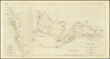
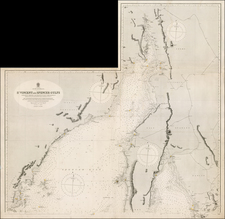
Manuscript Sea Chart of Australia Used By The Swedish Brig Nancy On Its Final Trip From Hong Kong To Melbourne in 1852-54.
An extraordinary artifact from the maritime history of mid-19th century Australia, a monumental sea chart of Australia made in Hong Kong for the Brig Nancy, bound for Melbourne via Hong Kong and Fremantle.
This monumental sea chart embraces all of Australia, including generous coverage of the surrounding seas. It also contains seven highly detailed insets of the main harbors of Australia. The quality of the draftsmanship is exceptionally fine, so as to successfully mimic the style and appearance of a printed chart.
The story behind the creation of the chart is fascinating, and illustrates the difficultly of obtaining reliable maritime maps in colonial outposts, far from Europe. Annotations on the present chart explain that it was drafted in Hong Kong in 1853 for the use of the crew of a Swedish ship, the brig Nancy, intending to sail to on to Australia. The Swedes noted the impossibility of purchasing printed charts of Australia in that port, so resolved to create their own chart, copied from borrowed printed charts then available in Hong Kong.
In 1853, Hong Kong was a bustling British trading port, however, the colony was barely a decade old. While it had its own basic printing establishments, duplicating advanced sea charts was far beyond the capabilities of Hong Kong printers. Even though Hong Kong had extensive shipping links to Australia, it seems that printed charts of Australia were not yet being imported from England in adequate quantities.
The chart includes a contemporary annotation in Swedish that explain its origins:
"Detta Kort är Kopierat af en Chines 1853 uti Hong Kong från ett Engelskt Kort som man fick låna från ett skepp. Emedan det fanns ej att få kjöpas på platsen. Carl Hagström".
("This chart is copied by a Chinese 1853 in Hong Kong from an English Chart that we could borrow from a ship. This since it could not be pur- chased at this place. Carl Hagström").
Whoever the 'Chinese' draftsman was, he was evidently superbly talented, as the rendering is remarkably skilled and precise. While it is possible that the "English chart" showing all of Australia, with large insets arrayed in such a manner, was a single chart, we have not been able to identify any chart that bears resemblance to the present manuscript. Rather, it seems that, by its content and style, the present chart is a composite of a series of charts issued by the Hydrographic Department of the British Admiralty, and engraved by J. & C. Walker. As these charts were often issued in numerous editions and forms, it is difficult to identify the precise issues from which the present work was copied. However, the overall outline of Australia appears to have been derived from updated versions of Phillip Parker King's Chart of the coast of Australia (London, 1824-26).
From 1819 to 1826, King completed the general hydrographic survey of Australia done by Matthew Flinders (1799- 1803). Subsequent hydrographers used King's charts as the base maps on which they placed their own observations, so continually updating the original charts. The chart(s) used for the general outline of Australia used here were clearly made after 1840, due to the appearance of the track of the "Ship Brightman to Australia. 1840," an immigrant ship which travelled from London to Adelaide. The inset maps were copied from printed British Admiralty charts by John Septimus Roe and John Lort Stokes.
As such, it is likely that the chart is based heavily on the surveys of John Wickham and John Lort Stokes. Stokes (sailing initially under the command of Wickham) took over the surveys of Australia's north and northwest following Wickham's poor health. Sailing in the Beagle on the authority of the Hydrographic Office, completed extensive surveys there and in Bass Strait, essentially completing the surveys made by Flinders, Baudin and King. Stokes maps appeared as Hydrographic charts beginning in 1844, and his journal accompanied by the 'first complete' map of Australia drawn by John Arrowsmith, appeared in print in 1846.
The present chart notably features the track, with the daily progress, of the Brig Nancy, delineated in red. An interesting contemporary annotation in Swedish reads:
"Briggen Nancy förd af Löjtnant C E Nordqvist på Resa från China till Melbourne. Anlöpt Swan River den 9 December 1853 för Watten och förfriskningar. Och har som det första Svenska fartyg som anlöpt denna plats. Antäcknat af 1st Styrman i nämnda Brigg. C Hagström".
("The Brigg Nancy under Lieutenant C E Nordqvist, traveling from China to Melbourne. Arrived Swan River the 9th of December 1853 for Water and refreshments. And has as the first Swedish ship arrived at this place. Written by 1st quartermaster in mentioned Brigg.")
Onboard the Nancy on its passage from Hong Kong was the sailor Peter Hedlund. The Nancy arrived at Freemantle, Western Australia on December 9, 1853, where Hedlund left the ship. He remained in Australia for the rest of his days. In 1863, while sailing aboard his vessel, the Mystery, he ran aground at a harbor on the northwestern coast of Western Australia. Hedlund noted that the haven, which he called Mangrove Harbor, would be the ideal location for a port town. The harbor was subsequently named 'Port Hedland' in his honor, and a town was established at the site in 1895. Today Port Hedland is Australia's largest port by weight, annually handling a vast tonnage of iron ore.
The Scuttling of The Brig Nancy In Melbourne Harbour in 1854
After Hedlund's departure in Fremantle, the Nancy travelled to Melbourne, where it arrived in February 1854. Customs port entries confirm the ship's arrival as February 23, 1854, however this appears incorrect. The shipping lists on board the vessel state that she berthed on February 20 and the Argus published the day after on February 21, notes her arrival at Melbourne, with Captain Nordqvist in command.
Upon arriving in Melbourne, the entire crew of the Nancy abandoned the ship, like so many at the time, seeking their fortune in the new gold fields in Victoria. Nancy lay with many other ships with similar fate, unable to find crews to sail the vessels back.
Nancy was bought by a Captain Kenney. who stripped her, sold all he could and sank her off the beach at St Kilda. Kenney turned her into St Kilda's first bathing ship. He advertised that you could bathe in her without fear of attack from fish (sharks). St Kilda became known as Kenneys bathing baths. Nancy remained in her scuttled position at St Kilda until 1912.
The Chart Stays With Captain Nordqvist
While Nancy met her end in Melbourne in February 1854, the chart saw continued use. The notes suggest that the Chart was used as follows:
The red tracks shows another vessel (possibly one that Nordqvist captained) with the following tracks:
- Departed Melbourne around 9 September 1854
- Arrived Fremantle around 16 October 1854
- Departed Fremantle around 15 November 1854
- Arrived back at Melbourne around 6 December 1854
- Departed Melbourne around 2 February 1855 probably on way to New Zealand
Ultimately, the chart was brought to market by a Swedish collector in 2013.
Conclusion
The present map is a unique artifact for both Hong Kong and Australian History. We are not aware of anything similar to this large and finely drafted sea chart of Australia, done under such fascinating circumstances, ever appearing on the market.