|
||

|

|
|

|
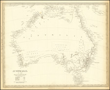
Blackie & Son's Map of Queensland, New South Wales, and Victoria, Circa 1880
The map produced by Blackie & Son around the year 1880 offers a vivid and intricate portrayal of Queensland, New South Wales, and Victoria. This map grants us a peek into the past, highlighting counties, rivers, mountains, islands, the outer boundary of the Great Barrier Reef, and the early roadways of the late 19th century. I
Physical Features and Infrastructure
The expansive Queensland, stretching on the northeastern part of the map, is marked by the winding, sprawling expanse of the Great Barrier Reef. The outer edge of this world-famous coral system is clearly delineated, a reminder of its significance to both local and global ecology.
Flowing through the territories are the prominent rivers, like the Murray and the Darling in New South Wales and Victoria, serving as lifelines to both human and natural habitats. The depicted mountain ranges, such as the Great Dividing Range, offer an idea of the terrain and its challenges during that era.
Perhaps most telling of the times are the roads. Roads open for traffic, those under construction, and those approved by parliament paint a picture of a country in the throes of infrastructural development. These pathways are evidence of the dreams and ambitions of a nation seeking connectivity and progress.
Brief History of the Three Regions up to 1880:
-
Queensland:
- Before becoming its own separate colony in 1859, Queensland was part of New South Wales. The establishment of Brisbane as a penal settlement in the early 19th century marked one of its initial European activities.
- The 1860s and 1870s saw a rush for gold, bringing wealth and population to Queensland. Alongside this, the region also became significant for its sugar industry, which unfortunately was heavily reliant on the labor of South Sea Islanders, many of whom were brought in under conditions akin to kidnapping and slavery.
-
New South Wales:
- As the site of the First Fleet's landing in 1788 and the establishment of the penal colony in Sydney, New South Wales holds the title of being the oldest European settlement in Australia.
- Throughout the 19th century, it underwent vast changes, experiencing its gold rush in the 1850s, leading to an economic boom and increased migration.
-
Victoria:
- Separating from New South Wales in 1851, Victoria soon experienced its gold rush, significantly impacting its population and wealth.
- Melbourne rapidly grew during this period, with the Gold Rush transforming it into one of the world's largest and wealthiest cities by the 1880s.
Conclusion:
The map of Queensland, New South Wales, and Victoria by Blackie & Son provides not just a geographical representation but a historical snapshot of Australia in the late 19th century. It is a testament to the determination of its people, the allure of its landscapes, and the promise of its resources. Through such maps, we not only understand territory but also the times, the aspirations, and the challenges faced by the people of that era.

![(Sydney) Plan du Comte de Cumberland (Nouvelle-Galles du Sud) [on sheet with] Plan des Iles Jerome [and] Plan des Iles Berthier](https://storage.googleapis.com/raremaps/img/small/77740.jpg)