|
||

|

|
|

|
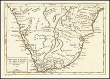
One of the Earliest Modern Maps of Angola
Finely detailed map of Angola, published in Lisbon in 1885.
This is one of the earliest obtainable maps of Angola, coming shortly after the Treaty with Britain which ratified Portugese hold on the modern country of Angola.
The map provides an early look at Angola's modern borders, along with a table showing its primary Agricultural and Mineral products.
Historical Overview
Even as late as the 1870s, European states still controlled only ten percent of the African continent, with all their territories being near the coast. The most important holdings were Angola and Mozambique, held by Portugal; the Cape Colony, held by the United Kingdom; and Algeria, held by France. By 1914, only Ethiopia and Liberia were independent of European control. By 1914, it had increased to 90 percent of the continent, with only Ethiopia (Abyssinia) and Liberia still being independent.
The present map shows Angola immediately after the so-called "Scramble for Africa" in 1884. The "Scramble for Africa" was the invasion, occupation, division, colonization and annexation of African territory by European powers during the period of New Imperialism, between 1881 and 1914. It is also called the Partition of Africa and the Conquest of Africa.
The Berlin Conference of 1884, which regulated European colonization and trade in Africa, is usually referred to as the starting point of the scramble for Africa. Consequent to the political and economic rivalries among the European empires in the last quarter of the 19th century, the partitioning of Africa was how the Europeans avoided warring amongst themselves over Africa. The latter years of the 19th century saw the transition from "informal imperialism" (hegemony), by military influence and economic dominance, to the direct rule of a people which brought about colonial imperialism.
In 1884, Britain, which up to that time had steadily refused to acknowledge that Portugal possessed territorial rights north of Ambriz, concluded a treaty recognizing Portuguese sovereignty over both banks of the lower Congo. The treaty, meeting with opposition in Britain and Germany, was not ratified. Agreements concluded with the Congo Free State, Germany and France in 1885-1886 (modified in details by subsequent arrangements) fixed the limits of the province, except in the south-east, where the frontier between Barotseland (Northern Rhodesia) and Angola was determined by an Anglo-Portuguese agreement of 1891 and the arbitration award of the king of Italy in 1905.