|
||

|

|
|

|
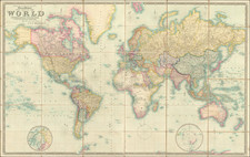
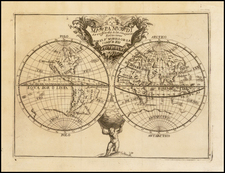
One of the the Earliest Surviving Examples of A Puzzle Map of the World
Fine old color example of a dissected map of the World, published by John Wallis in London, based upon a map created by John Kitchin.
The present map is one of the two or three earliest surviving examples of puzzle maps of the world.
The cartographic details in the map show the world immediately after the third voyage of Captain James Cook, with Cook's tracks meticulously shown on the map. Hawaii is located, New Zealand is shown as two large and accurately placed islands and a more complete outline of Australia is shown, although Tasmania is still attached to the mainland of Australia.
We note only a single reference to the map in The Curious Map Book, by Ashley Baynton Williams, page 100, where he describes a copy in the British Library with the same imprint on the map as this example, but also including an attribution "By Thomas Kitchin Hydrographer to His Majesty . . . " The illustration of the British Library example suggests that it is incomplete (lacking 3 pieces).
The only earlier surviving dissected world map attributed to John Spilsbury (publisher) and Robert Sayer (mapmaker) in the National Library of Australia: http://http://acms.sl.nsw.gov.au/album/albumView.aspx?itemID=936571&acmsid=0
Overview of Puzzle Maps
The earliest surviving jigsaw, produced in London in 1766, was a hand-made, dissected map of Europe which was designed as an educational tool, rather than a toy.
The first jigsaws were known as 'dissected puzzles'. The term 'jigsaw' was not used until the 20th century. It refers to the mechanical fretsaw used to cut the puzzle. Before its invention in about 1870 puzzles had to be cut by hand. Because of this, antique puzzles have quite large pieces, and it was not possible to cut the highly interlocking pieces which characterize the modern jigsaw puzzle.
Early jigsaws from the 18th century were devised as teaching aids for the children of well-to-do families, and therefore featured educational subjects.
A London map-maker and engraver named John Spilsbury is credited with being the first person to create dissected puzzles designed for children. A London street directory of 1763 describes him as a 'Map Dissector in Wood, in order to facilitate the Teaching of Geography'. One of his first puzzles was called Europe divided into its Kingdoms. The pieces were cut along the borders of the countries, so that children would soon learn to identify them by their shapes.
Other map puzzles followed: England and Wales divided into their Counties (1767) and The World (1772), and this novel idea for the education of children began to catch on. About half the 18th-century puzzles were maps but other subjects were soon introduced.
Publisher Information
The present map would seem to be virtually unrecorded survival. It would seem possible that the map and box are not a match, as the map is unquestionably a survival from 1787, with imprint, while the box provides information relevant to John Wallis Junior, with addresses of 188 Strand and Warwick Square.
The map imprint states:
Published as the Act directs, Jany. 1st 1787 by Proprietor J. Wallis at his Map Warehouse, Ludgate Street, London.
However, the box title is:
Wallis's New Dissected Map of the World Engraved from the latest authorities for the use of Young Students in Geography. Published by John Wallis Jun. 188 Strand ? J Wallis Junr. Warwick Sqr.
John Wallis Sr. (died 1818) was an English board game publisher, bookseller, map/chart seller, print seller, music seller, and cartographer. With his sons John Wallis Jr. and Edward Wallis, he was one of the most prolific publishers of board games of the late 18th and early 19th centuries.
Wallis's company occupied a number of sites in London, England including:
- 16 Ludgate Street (under the name "Map Warehouse") from 1775.
- 13 Warwick Square (under the name "Instructive Toy Warehouse") from 1805.
- 42 Skinner Street, Snow Hill - this address was mainly used by Edward Wallis when working alone or when working with his father, in those cases publishing as "Wallis and Son" or "John & Edward Wallis".
- 188 The Strand - this address being used solely by John Wallis Jr.
Ashley Baynton Williams, a noted map and English printing history scholar, provides the following information:
- John Wallis Jr. was at 188 Strand from 1806 to 1808
- John Wallis Sr. was at 13 Warwick Square between 1805 and 1811.
Based upon the foregoing, the likely dating of the box (based on the label) would be 1806-1808. It is highly unlikely that the map itself, dated 1787, would have been published at such a late date, as John Wallis was already publishing a newer world map by 1800:
1800 John Wallis Dissected World Map: https://www.loc.gov/resource/g3201a.ct006144/
1812 John Wallis Jr. Dissected World Map: https://www.loc.gov/item/85694395/
Early Owner & Inscription
The inscription inside the box gives some further information.
Inscribed in the bottom of the box are the words"
Outside Pieces 29 / Inside Do. 40 } total 69
H ? L Daller, from his sister L.M. Daller 1811
The dating of 1811 is consistent with the John Wallis Junior attribution for the box. The British Museum catalog for John Wallis Junior places him at 72 Fleet Street in 1807 and 188 Strand in 1814.
While we cannot provide a definitive explanation of the dating differences, it remains a remarkable artifact.
![(California Lithography) N.S.G.W. Certificate of Membership. This is to Certify that [blank] is a member of Native Sons of the Golden West](https://storage.googleapis.com/raremaps/img/small/93308.jpg)