|
||

|

|
|

|
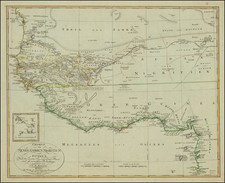
One of the earliest maps of Sierra Leone.
Large format map of Sierra Leon, at the outset of the Hut Tax War of 1898.
The map was constructed only shortly after the 1895 Paris Treaty which established its boundaries at the time.
The survey was prepared by Mr. E. de P. O'Kelly, FRGS, in 1897-98.
The map delineates:
- Districts subject to the Laws of the Colony
- Boundary of Territory Subject to the Protectorate Ordinance 1897
- Boundaries of the Districts of the Protectorate
- Boundary of French Territory
- Boundary of Liberia
Overview of Colonial Sierra Leone
In 1800 Sierra Leone was still only a small colony extending a few miles up the peninsula from Freetown. The bulk of the territory that makes up present-day Sierra Leone was still the sovereign territory of indigenous peoples such as the Mende and Temne, and was little affected by the tiny population of the Colony. Over the course of the 19th century that gradually changed: the British and Creoles in the Freetown area increased their involvement in-and their control over-the surrounding territory by engaging in trade, treaty making, and military expeditions. Trade was the driving force; the treaties and military expeditions were undertaken primarily to promote and increase it.
In their treaties with the native chiefs the British were largely concerned with securing local peace so that commerce would not be interrupted. Typically, the British government agreed to pay a chief a stipend in return for a commitment from him to keep the peace with his neighbours; other specific commitments extracted from a chief might include keeping roads open, allowing the British to collect customs duties, and submitting disputes with his neighbours to British adjudication. In the decades following Britain's prohibition of the slave trade in 1807, the treaties sometimes also required chiefs to desist from slave trading. Suppression of slave trading and suppression of inter-chiefdom war went hand-in-hand because the trade thrived on the wars (and caused them). Thus, to the commercial reasons for pacification could be added anti-slavery ones.
When friendly persuasion failed to secure their interests, the British were not above (to borrow Carl von Clausewitz's phrase) "continuing diplomacy by other means". At least by the mid-1820s, the army and navy were going out from the Colony to attack chiefs whose behaviour did not conform to British dictates. In 1826, Governor Turner led troops to the Bum-Kittam area, captured two stockaded towns, burnt others, and declared a blockade on the coast as far as Cape Mount. This was partly an anti-slaving exercise and partly to punish the chief for refusing territory to the British. Later that year acting-Governor Macaulay sent out an expedition which went up the Jong river and burned Commenda, a town belonging to a related chief. These excursions were typical of those that continued throughout the century: army or frontier police, with naval support if possible, would bombard a town and then usually torch it after the defenders had fled or been defeated. Where possible, local enemies of the party being attacked were invited by the British to accompany them as allies.
In the 1880s, Britain's intervention in the hinterland received added impetus because of the "Scramble for Africa": an intense competition between the European powers for territory in Africa. In this case the rival was France. To forestall French incursion into what they had come to consider as their own sphere, the British government renewed efforts to finalize a boundary agreement with France and January 1, 1890, instructed Governor Hay in Sierra Leone to get from chiefs in the boundary area, friendship treaties containing a clause forbidding them to treat with another European power without British consent.
Consequently, in 1890 and 1891, Hay and two travelling Commissioners, Garrett and Alldridge, went on extensive tours of what is now Sierra Leone obtaining treaties from chiefs. Most of these were not, however, treaties of cession; they were in the form of cooperative agreements between two sovereign powers.
In January 1895, a boundary agreement was signed in Paris, roughly fixing the line between French Guinea and Sierra Leone. The exact line was to be determined by surveyors later. As Christopher Fyfe notes, "The delimitation was made almost entirely in geographical terms-rivers, watersheds, parallels-not political. Samu chiefdom, for instance, was divided; the people on the frontier had to opt for farms on one side or villages on the other."
More generally, the arbitrary lumping together of disparate native peoples into geographical units decided on by the colonial powers, has been an ongoing source of trouble throughout Africa. These geographical units are now attempting to function as nations but are not naturally nations, being composed in many cases of peoples who are traditional enemies. In Sierra Leone, for example, the Mende, Temne, and Creoles remain as rival power blocs between whom lines of fission easily emerge.
In August 1895, an Order-in-Council was issued in Britain authorizing the Colony to make laws for the territory around it, extending out to the agreed-upon boundary (which corresponds closely to that of present-day Sierra Leone). On August 31, 1896 a Proclamation was issued in the Colony declaring that territory to be a British "Protectorate". The Colony remained a distinct political entity; the Protectorate was governed from it.
Most of the Chiefs whose territories the "Protectorate" subsumed did not enter into it voluntarily. Many had signed treaties of friendship with Britain, but these were expressed as being between sovereign powers contracting with each other; there was no subordination. Only a handful of Chiefs had signed treaties of cession, and in some of those cases it is doubtful whether they had understood the terms. In remote areas no treaties had been obtained at all.
Strictly speaking, a Protectorate does not exist unless the people in it have agreed to be protected. The Sierra Leone Protectorate was more in the nature of a unilateral acquisition of territory by Britain.
Almost every chieftaincy in Sierra Leone responded to the British with armed resistance. The Protectorate Ordinances (passed in the Colony in 1896 and 1897) abolished the title of King and replaced it with "Paramount Chief"; chiefs and kings had formerly been selected by the leading members of their own communities, now all chiefs, even paramount ones, could be deposed or installed at the will of the Governor; most of the judicial powers of the chiefs were removed and given to courts presided over by British "District Commissioners"; the Governor decreed that a house tax of 5 shillings to 10 shillings was to be levied annually on every dwelling in the Protectorate. To the chiefs, these reductions in their power and prestige were unbearable. When, in 1898, attempts were made to actually collect the tax, they rose up, first in the north, led by a dominant Temne chief called Bai Bureh, and then in Mende country to the south. The two struggles took on quite different characteristics.
Bai Bureh's forces conducted a disciplined and skillfully executed guerrilla campaign which caused the British considerable difficulty. Hostilities began in February, 1898. Bureh's harassing tactics confounded the British at first but by May they were gaining ground. The rainy season interrupted hostilities until October, when the British resumed the slow process of eliminating the African's stockades. When most of these defences had been eliminated, Bureh was captured or surrendered in November.
The Mende war was a mass uprising, planned somehow to commence everywhere on 27 and 28 April, in which almost all "outsiders"-whether European or Creole-were seized and summarily executed. Although more fearsome than Bai Bureh's rising, it was amorphous, lacked a definite strategy, and was suppressed in most areas in two months. Some Mende rebels in the center of the country were not beaten until November, however; and Mende king Nyagua's son Maghi, in alliance with some Kissi, fought on in the extreme east of the Protectorate until August 1899.
The two risings together are referred to as the Hut Tax War of 1898. The principals, Bai Bureh, Nyagua and Be Sherbro (Gbana Lewis), were exiled to the Gold Coast on 30 July 1899 and a large number of their subordinates were executed.
![X. b [Congo]](https://storage.googleapis.com/raremaps/img/small/93299.jpg)
![The Prospect of the Island of Goeree & the Fort Vermandoise alias St. Michael (with) A Plan of the Island Goeree in Nigritiae (and) [Plan of Fortifications]](https://storage.googleapis.com/raremaps/img/small/92044.jpg)