


|
||

|

|
|

|
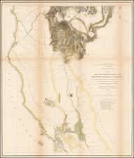
Rare 1876 edition of Bancroft's map of California & the Southwest.
The map is hand colored by counties and shows tremendous detail, one of the best maps of the Western United States published West of the Mississippi during the period. Early roads, towns, rivers, mountains, mines, Indian Villages, Springs, lakes, islands, railroads, railway stations, military camps and forts and a host of other details rarely seen on maps of the period.
First published in 1864, Wheat notes that this map and the larger map of the Pacific State established the rising HH Bancroft house as the greatest map publisher of the Pacific Coast, and remarks that the size of the maps is so large and so overflowing with detail that it is utterly impossible to describe their minutiae.
This 1876 edition is one of the last editions to be published using the original 1864 format. Originally published by HH Bancroft & Co. and William H. Knight, the publisher is now shown as A.L. Bancroft & Co. An example of the first edition of the map can be seen here: /gallery/detail/8461
The comparison of the two maps is a fascinating study in the evolution of both the topographical knowledge of California and the West, during this time period, and the addition of established lines of transportation, mines, cities and other man made changes. This change can be seen in San Diego County, where there are now several completed and proposed railroad routes (the Southern Pacific, for example, having just completed its 2 Southern California Branches in 1876 and the proposed route of the Texas Pacific RR is now shown, whereas in 1864, only the Proposed (and ultimately significant changed) route of the Southern Pacific is shown). Similarly, the extensive but vague mountain ranges of Southern California have been replaced with a much more exacting depiction, and a massive "Salt Lake" is now shown in the southeastern part of California, a fantastic pre-cursor to the reflooding of the Salton Sea, which did not occur until 1905.
Similar changes appear in San Bernardino County, where the massive vague mountain ranges have been replaced with an open clean desert, the new Proposed route of the Southern Pacific from Los Angeles through the Mojave Desert is shown and numerous mining regions are now in evidence.
Significant changes can also be seen in Utah, Arizona and Nevada. The Utah-Nevada border has been moved 2 degrees eastward (reflecting the anti-Mormon sentiments of Congress during the 1860s) and the railroad system around the Salt Lake area has evolved tremendously since the arrival of the Union Pacific and the completion of the Transcontinental Railroad.
In Nevada, the mining boom that began in Virginia City and Washo & Storey Counties has no spread throughout the state, with many new towns, mining districts, roads and a remarkable improvement in Nevada's topography in evidence.
In Arizona, the old county system which extended across Arizona and New Mexico is gone, with the early modern county configurations shown. The topography has changed significantly and the mining districts and population in the area of Prescott is much in evidence, along with significant planning of railroads and a much evolved system of wagon roads.
Similar remarkable changes can be seen throughout the map. Wheat notes that the student must go to the maps themselves, as they are so rich with source information as to defy description.
Provenance: Warren Heckrotte Collection

![[ Upper California, Texas and Mexico ] Carte Generale Du Mexique Ed Des Provinces-unies De L'Amerique Central ou Guatemala](https://storage.googleapis.com/raremaps/img/small/81604.jpg)
![[ Before The Salton Sea ] [ Official Map of San Diego County compiled from latest official maps of U.S. surveys, railroad and irrigation surveys, county records, and other reliable sources . . . Northeast Sheet ]](https://storage.googleapis.com/raremaps/img/small/101378.jpg)