|
||

|

|
|

|
A Rare French Scientific Exploration of the California & Nevada -- Mining - Geology -- Petroleum
First edition of this single part of a lengthy, bibliographically complex set published by the French government, with the present part relating to geology and mining in California and Nevada. These reports were included in the larger work on Mexico by the Commission Scientifique du Mexique because California and Nevada were formerly part of Mexico.
Mining in California and Nevada was of intense international interest at the time - in 1859 silver was discovered at the Comstock Lode in Virginia City, and thousands of miners, loggers, and traders rushed to the region and towns sprang up, necessitating a railroad between Virginia City and Truckee through the Washoe Valley.
The work was published during France's ill-fated attempt to establish Imperialism in Mexico. Originally sent out under the shadow of the French Army, the work of the Scientific Mission is of monumental importance. The materials accumulated by M. Bocourt and his Fellow-Naturalists, were deposited in the National Museum of the Jardin des Plantes, and the elaboration of them entrusted to special workers in the different branches of science. In total, the work was issued in a number of volumes between 1870 and 1894.
The maps in this work have been well appreciated in academic circles, but until recently had escaped the notice of modern collectors. As noted by Jennings:
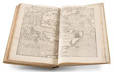
The next geological map of California deserving of mention in this chronological description is a remarkable one, and possesses a very interesting history. This map, prepared by Edmond Guillemin-Tarayre in 1867 and published in Paris in 1871, is but one of 17 beautiful plates accompanying an obscure volume entitled "Description des anciennes possessions. Mexicaines du nord, Mission Scientifique au Mexique et dane I'Amcrique Central, Geologie." This publication apparently Volume 2 of several volumes describing the geological, botanical, archeological, zoological, and linguistic researches of a French scientific mission to Mexico, California, and Nevada. The geology volume was the first to be published, and is confined to California and Nevada; however, it very strangely was
left unfinished for the text stops abruptly after 216 pages, in the middle of a hyphenated word!It is interesting to note that this geologic map and volume on geology are not listed in the earliest bibliographies of geologic maps of California. For example, they are not mentioned in Marcou's "Catalog of geological maps of America" (U.S. G col. Survey Bull. No. 7) published in 1884, or Vodges' "Bibliography relating to the geology, paleontology, and mineral resources of California" (California State Mining Bur. Bull. No. 10) published in 1896. Although the U.S. Geological Survey's "Geologic literature on North America, 1785 to 1918", published in 1923, enters Guillemin's publications, and these are consequently
picked up and relisted by later indexes, nothing could be found in the American literature about this geologist and this excellent scientific survey.The volume on geology (1871) is organized into two sections—the first on Nevada, and the second (and unfinished part) on California. Beginning with
geographical data on these states, succeeding chapters treat the geology, mining districts, and metallurgical processes, and the volume ends abruptly in a discussion of the gold veins of the Sierra Nevada.However, it is the plates which are probably of greatest interest to us—seven on California, nine on Nevada, and one of the southwestern United States. The California plates include two hand-colored geologic maps of parts of California (an area in central California, and an area in the southern part of the State), a colored lithographic geologic map, and a metallurgic map of California and Nevada, and four engravings. The engravings illustrate cross sections of Sierran gold mines, the New Almaden quicksilver mine, and mining equipment used in the recovery of gold and quicksilver.
A notation on the geologic map of California indicates that it was based on the geologic investigations of the Pacific Railroad, the Geological Survey (California's Whitney Survey), and the observations of the author (fig. 2). The map bears the date 1867. The geology is portrayed in a most impressive manner by ten geologic units utilizing both color lithography and letter symbols, the latter making it easier to correctly identify the various units, not always easy to do on early geologic maps. All of California is depicted by geologic map units, but the southeastern comer of the state is cut off by the map border. The base map on which the geology is plotted is very good for its time. It identifies a large number of towns, rivers, and lakes, and indicates the names of the counties but does not attempt to show their boundaries. The geologic interpretation is remarkably good. In most respects this geologic map is much more accurate than any of the maps presented prior to that time, and was not surpassed by any other geologic map of the State for several years following its publication. What a pity
that such an informative map should have been buried for so long in an obscure foreign publication!The accompanying "metallurgic" (sic) map bears the same date, 1867, and is credited as being based on the "latest documents." Using a seven-unit legend, it portrays the gold-, silver-, copper-, and mercury-bearing belts, the lignite basins, the bituminous shales, and mineral springs—a most remarkable attempt to emphasize and locate the economic geology of the State at such an early date!
The colored plate entitled "Geological sketch map of the metalliferous regions of California," scale 1:1,000,000, encompasses central California. It is interesting to note that the text states that this map has been constructed from the observations of Tyson, Trask, various members of the Geological Survey (California's Whitney Survey), and from the reconnaissance of the French scientific mission. Mr. Rémond of the California Geological Survey was singled out as a source of information on the boundaries of the Tertiary strata. This map stands in contrast to another plate, at the same scale, of southern California (Santa Barbara, Los Angeles, and San Diego Counties) which is referred to in the title as the "oil region."
Contents
The maps and plates in this report relate primarily to mining and geology, but often they contain other details on the region before many of the towns and mining operations were abandoned.
The plates were drawn by Erhard Schieble and all but one were printed by Lemercier. They are superb renditions of their subjects by some of the more accomplished mapmakers and view makers of the time, printed in a country at the height of its excellence in this type of work.
A partial list of the maps and plates includes:
-
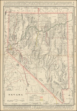
Carte de la Haute Californie et de la Nevada dressee par E. Guillemin-Tarayre d'apres les derniers documents 1867. 28.4x20.9 cm. California, Nevada, and part of Arizona.
-
Types des Tribus de Grand-Bassin I.II. Shoshone. III. Washoe. IV.V. Pah-Utah. 25.5x17.7 cm. Lithograph from photographs, on tinted ground. Native Americans of the region (including Utah).
-
Carte de Panoramique de la Region metallifere de Washoe (Etat de Nevada) par E. Guillemin-Tarayre.... Circular panorama measuring 49 cm. Bird's-eye panorama of the Washoe mining district; inner circle colored to indicate types of terrain; outer circle consisting of an uncolored view of mountains, towns, mining operations, roads, etc. Named locations include Lake Tahoe, Pyramid Peak, Silver Mountain, Carson River, Morning Star, Mount Washoe, etc.
-
District of Washoe Plan et Coupe du Filon de Comstock 1864.... 25.5 x 43.5 cm.
-
Nevada Geologie et Mineralogie. 25.5 44 cm. Uncolored plate with 8 elements, including profile of the Mono Lake area, District of Pine Forest, profile of Virginia City, geysers at Mono Lake, and mining shaft at Antelope.
-
Carte Metallurgique de la Haute Californie et de la Nevada dressee par E. Guillemin-Tarayre d'apres les derniers documents 1867. 28.5x21 cm. Metallurgical map keyed in yellow, brown, green, grey, and blue.
-
Carte Geologique de la Haute Californie et de la Nevada dressee par E. Guillemin-Tarayre D'apresles recherches des Geologues du Pacific Road, du Geological Survey et celles de l'Auteur 1867. 28.5x21 cm. Geological map keyed with shades of green, blue, pink, brown, sienna, etc.
With 20 lithographed and engraved maps, plans, profiles, and plates (some in color or on tinted grounds, several folding).
![[ Early Automobile Tourism -- Pacific Coast Highways ] (Strip Maps, etc.)](https://storage.googleapis.com/raremaps/img/small/81461.jpg)