


|
||

|

|
|

|
Previously unknown manuscript map drawn by one of the most important modern Pacific Ethnologists.
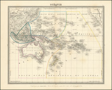
A superbly crafted and detailed manuscript chart of the Pacific showing Australia and New Zealand. The routes of many of the important Pacific voyages are shown, accompanied by a legend identifying them at the bottom, written in Partington's own hand.
The name Partington is indelibly connected with the history of the Pacific, New Zealand and Australia: William Henry Thomas Partington (c.1855-1940) left an exhaustive and historically important collection of hundreds of photographic portraits of the Maori from the Whanganui River area, now mostly housed in the Whanganui Museum; and James Edge Partington (1854-1930), a noted British anthropologist whose passion focused on the customs of predominantly the Pacific Islanders and the history of Australasia. Edge-Partington's extraordinary collection of artefacts from the Pacific Basin region was eventually donated to the British, Australian and New Zealand national libraries. As well, he amassed a substantial collection of books relating to Australasian discovery, in particular books focusing on Australia.
Partington was a fine draughtsman and published several books illustrated by his own hand. His best-known work, An Album of the Weapons, Tools, Ornament, Articles of Dress etc of the Natives of the Pacific, was issued for private circulation and in the first printing is extremely rare. In 2009, Bonhams sold an example for over AUD $50,000.
Born in Brighton Grove, Manchester in 1854, Partington was educated at Rugby where he qualified as a solicitor. His passion for the Pacific Islands was instigated by an extensive three-year expedition to the region and it was during this expedition that he began amassing his collection of South Seas artifacts.
Partington donated a great amount of his time as a volunteer at the ethnological department of the British library. A long standing member of the London Royal Anthrological Institute, he soon developed a reputation as a world authority on Pacific Ethnology.
This fine manuscript map of the Pacific is creatively graphic in design, with the routes of the various Pacific voyages carefully plotted and the Pacific Islands extensively labelled. A legend in Partington's own hand, identifies the various routes plotted on the map. Perhaps the map was being constructed for use in another of Partington's publications, however its unfinished nature suggests that he may have died before the map was completed. Freycinet's name is written in Partington's hand in pencil, with several dates also annotated in pencil. Vancouver's name is written in ink in the legend with no date and without his route plotted on the map.
The countries are all solidly coloured in with black ink and with no nomenclature or geographic detail. Partington clearly wanted the focus to be concentrated on the Pacific Islands and the European explorers who were responsible for the identification and ultimate charting of the Pacific Basin Islands.
A pencil annotation in a later hand in the bottom margin of the map notes, "H.Partington's Collection of South Seas...c.1930".
![[ Australia ] Australien](https://storage.googleapis.com/raremaps/img/small/98068.jpg)

![[ Promoting the Products and Industries of New Zealand ] New Zealand -- Compiled by The New Zealand Map Co.](https://storage.googleapis.com/raremaps/img/small/102104.jpg)