
The item illustrated and described below is sold, but we
have another example in stock. To view the example which
is currently being offered for sale, click the
"View Details" button below.


|
||

|

|
|

|
Stock# 43311
Description
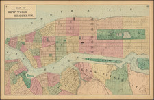
Fredrick W. Beers' Map of New York City and Brooklyn, published in 1873.
The map shows New York City to 115th Street and parts of Brooklyn and Queens.
Shows individual buildings, parks, and street names. Exceptional detail in Central Park and Queens, areas generally neglected by earlier maps of the city. Blackwood Island (Roosevelt Island) is beautifully detailed with a Hospital shown at the southern tip of the Island where today we see only a decrepit, if glorious, ruin. Shows the beginning of the Long Island Railroad at Hunter's Point and the individual buildings of the Lunatic Asylum on Ward's Island.
![[ Central Park ]](https://storage.googleapis.com/raremaps/img/small/75716.jpg)