|
||

|

|
|

|
Cheap Print For The Masses!
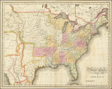
Virtually unknown Revolutionary War Broadside Map, "Printed & Sold by R. Marshall, No. 4 Aldermary Church Yard London, of whom may be had variety of other Maps & two Sheet Prints &c."
Very rare 2-sheet broadside map published by Richard Marshall, in response to the demand for information concerning the American Colonies at the outset of the American Revolution and intended for distribution in America.
One of the most intriguing elements of this map is that it was, with some certainty, intended for sale to both the British and American "general consumer" market. The map is the work of the Dicey-Marshall printing firm, which traces its roots back to the 1730s. The firm was the most prolific producer of "cheap print," much of which was exported to America. The firm is generally regarded as the most important printer and seller in the eighteenth century of printed material for the masses in the second half of the 18th Century in America and Great Britain. Richard Marshall joined the Dicey firm in about 1753 and remained a partner until the dissolution of the firm in 1778.
While published in London, the Dicey-Marshall printing house counted sales to the British Colonies in North America as a very important part of their business. The firm was exporting printed material to the American market very early in its history. Material from the Dicey Catalog has been tracked to advertisements by Matthew Clarkson and the Pennsylvania Gazette as early as 1754. In his work the Dicey and Marshall Catalog, R.C. Simmons notes:
"Setts of maps" were offered in a 1755 advertisement as "Imported in the ship Carolina, Capt. Mesnard, and in the Pennsylvania, Capt. Lyon, from London, and to be sold by ALEXANDER HAMILTON, cheap for ready money, or three months credit, at his store in Water street, on William Fisbourn wharff."
Moreover, as noted by Simmons in the section entitled The Diceys and the transmission of cheap print to North America:
Richard Marshall, after his partnership with Cluer Dicey ended, maintained a strong interest in the export trade, describing himself in the 1770s as "printer and bookseller to the good children of Great Britain, Ireland, and the plantations." Cheap texts and cheap images as well as medicines were imported into North America in some quantity. . .
The material may have even been part of the print sold by Benjamin Franklin:
Franklin advertised "cheap Pictures engraved on Copper Plate of all Sorts of Birds, Beasts, Fishes, Fruits, Flowers, &c. useful to such as would learn to draw" in 1730 and in 1739 a "great variety of maps and prints."
Simmons notes:
The likelihood that many of the prints that were sold in colonial America were Dicey or Dicey and Marshall productions seems strong [and that] Imports accounted for the bulk of the popular texts, images and maps, not to mention patent medicines, that were sold in eighteenth-century British America.
See generally: www.diceyandmarshall.bham.ac.uk/refframe.htm
One of the most interesting features of the map is its incorporation of 3 views and 9 plans of important American Cities and harbors. The views include New York, Quebec and Mexico City, each of which is drawn from Henry Popple's 20 sheet map of the British Plantations of North America. Of the 9 harbor plans, the Boston, Charleston, New York and Kingston, Jamaica plans are drawn from Popple, where as Cape Breton, Chibucto Harbor/Halifax, Cartagena, Porto Bello, and Havana are from different sources.
In all, the map incorporates views and plans of the following American Cities:
- Quebec
- A Plan of Chibucto harbour & City of Halifax in No. America
- The Islands of Cape Breton
- The City & Harbour of Cartagena
- Harbour of New York
- Charles Town in South Carolina
- The Town & Harbour of Boston in New England
- New York
- Mexico City
- The City & Harbour of Havana
- Kingston Harbour in Jamaica
- The Town & Harbour of Porto Bello
The only modern reference to the map would appear to be a reference giving a date of 1741, for one edition of the map in the Percy Rivington Pyne Catalogue of Engraved Views, Plans &c. of New York, item #14, references a view of New York which matches the description of the present view, with a nearly identical title. The description references a total of 3 views (New York, Quebec and Mexico City), but only 8 plans (excluding the Cape Breton Islands). The entry reads:
New York | References. | (Column of fourteen names) | . New York is situated in 40 deg . 40 min . N. Lat d . on an Eminence (thirteen lines) | A new map of | North America, | wherein is exactly described all ye European | settlements, with whatever else is remarkable | in the West Indies, | from the latest and best Discoveries ; | Adorn'd with j views | and plans | of the most considerable [ Towns, Harbours, | &c. In border, at upper right of map. The other views are Quebec and Mexico, and the plans are Chihucto Harbour and City, Halifax, Cartagena, Harbour of New York, Charles Town in South Carolina, Boston in New England, Havana, Kingston Harbour in Jamaica and Porto Bello. Excessively scarce.
We note that the John Carter Brown Library holds an edition published by William & Cluer Dicey in 1755. The British Library holds a copy of the map which is undated, but estimated at 1770. The University of Minnesota apparently holds a copy of this state of the map, although its description does not mention the Cape Breton Island inset.
![[Eurpean and American Air Routes] TWA Trans World Airline U.S.A. • Europe • Africa • Asia Air Routes](https://storage.googleapis.com/raremaps/img/small/89027.jpg)