|
||

|

|
|

|
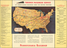
One of the Rarest 19th-Century Atlas Maps of the United States.
Shows the Ephemeral Territories of Bexar and Young in West Texas.
Rare map of the United States, depicting elaborate networks of railroads, published by George F. Cram in Chicago in 1878.
The Midwest is a veritable spider web of rail lines, but in the West, only the Union Pacific has fully crossed the nation. Unconnected lines in Washington and Oregon are illustrated.
Territories of Bexar and Young
Interestingly, in Texas, the map names "Territory of Young" and "Territory of Bexar". These were place-holder organizing structures used before the land was subdivided into counties. The use of "Territory of Bexar" is anachronistic for 1878, as all of that land had been divided into counties four years earlier. In fact, much of what is shown as "Territory of Bexar" was never in the Bexar Land District, having immediately been divided into Presidio and El Paso Counties, when county division reached that far west for the first time in 1850. For some reason, both of these "Territories" show up on maps primarily in the late 1870s.
Rarity
This is among the rarest of the 19th-century atlas maps of the United States. We have never offered it for sale before (1992-2024).
No examples listed in OCLC. We note only the David Rumsey copy.
George F. Cram (1842-1928), or George Franklin Cram, was an American mapmaker and businessman. During the Civil War, Cram served under General William Tecumseh Sherman and participated in his March to the Sea. His letters of that time are now important sources for historians of the Civil War. In 1867, Cram and his uncle, Rufus Blanchard, began the company known by their names in Evanston, Illinois.
Two years later, Cram became sole proprietor and the company was henceforth known as George F. Cram Co. Specializing in atlases, Cram was one of the first American companies to publish a world atlas. One of their most famous products was the Unrivaled Atlas of the World, in print from the 1880s to the 1950s.
Cram died in 1928, seven years after he had merged the business with that of a customer, E.A. Peterson. The new company still bore Cram’s name. Four years later, the Cram Company began to make globes, a branch of the business that would continue until 2012, when the company ceased to operate. For the final several decades of the company’s existence it was controlled by the Douthit family, who sold it just before the company was shuttered.
![Colton's United States Shewing Military Stations, Forts &c. . . . 1861 [Shows Colorada!]](https://storage.googleapis.com/raremaps/img/small/95088.jpg)
![[ Catholic Dioceses and Missions in the United States ] Karte der katholischen Dioecesen und der en Missionen in Nordamerika nach den nuesten geographischen Angaben... 1845](https://storage.googleapis.com/raremaps/img/small/98630.jpg)
![[ United States ] Carte Speciale, Historique et. Geographique De La Republique Des Etats-Unis De L'Amerique Du Nord](https://storage.googleapis.com/raremaps/img/small/98460.jpg)