|
||

|

|
|

|
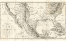
Scarce map of the Western US from Traugotte Bromme's Hand Atlas. Bromme was best known for his American Travel Guides, which began in the 1830s and continued for several decades, providing German Emigrants w/excellent information on the US. This map shows Bormme's characteristic attention to detail, especially identifying roads and placenames, especially in Texas, California and in the mining regions of the Rocky Mountains. Excellent detail on both sides of the Rockies. The name Arizona makes an early appearance in New Mexico Territory. Dozens of forts and Indian Tribes named throughout. Excellent attention given to the Mountains, including Humboldt's Mountains and many other ephemeral names. A wonderful collector's map.
Traugott Bromme was a traveler and publisher best known for this immigration guides for German migrants. Born in Anger, in Saxony, Traugott was orphaned at a young age. He emigrated to the United States at age eighteen. There he studied medicine, traveled extensively, and supposedly served as a surgeon in the nascent Colombian Navy and was imprisoned in Haiti. He returned to Germany in 1824, where he became a partner in his brother-in-law’s bookshop in Dresden. He began to publish books on the topic of immigration at this time.
In 1833 Bromme returned to the United States, this time to Baltimore where he took up a partnership in a publishing house, Scheld and Company. Here he began to publish his guidebooks targeting German immigration to America, which included maps after those of Henry Schenck Tanner. By 1840, he had again returned to Germany, starting a bookshop in Stuttgart. In 1846 he once again sailed to America, spending three years there. By 1849, he was back in Germany and seemingly returned to publishing. All of his outputs were geographic in nature and include several wall maps.

![Fly to a Holiday on Continental [Golden Jet Souvenir Flight Map]](https://storage.googleapis.com/raremaps/img/small/90328.jpg)
![(Mexican War) [ Proposed United States - Mexico Military Border - January 1848 ]](https://storage.googleapis.com/raremaps/img/small/99246.jpg)