
This item has been sold, but you can enter your email address to be notified if another example becomes available.


|
||

|

|
|

|
Stock# 4064
Description
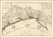
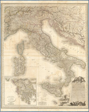
Large highly detailed map of Italy, including Corsica, Sardinia and Malta. Includes notes of various routes and distances by sea, as well as towns, railroads, roads, rivers, mountains and other geographical notes. The Papal States and Malta are colored differently from the rest of the map, for reasons which are not explained. Nice topographical detail. Dufour's Atlas Universel was one of the great large format French atlases of the mid 19th Century.
![[The Travels of Paul] Tabula Geographica, in qua omnes regiones, urbes, oppida, et loca describuntur, quorum mentio fit in Actis et Epistolis Apostolotum, et Apocalypsi; de integro multis in locis emendata, ac regionum limitibus distincta, auct. Pet. Planc. . . .](https://storage.googleapis.com/raremaps/img/small/77970.jpg)