


|
||

|

|
|

|
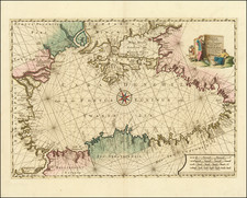
Plancius' Map of the Eastern Mediterranean Showing the Travels of Paul The Apostle
Finely engraved map of the eastern Mediterranean, engraved by Baptista Van Deutecum and printed in Amsterdam for Ian Evertsz Cloppenborch.
The map shows the regions around the Mediterranean; present-day Italy, Greece, Turkey, Syria, Israel, northern Egypt and the northern coastline of Africa.
The map is ringed by 15 images of scenes from the Acts of the Apostles and the Revelation of John, including:
- 1 - Foundation of the Christian congregation / outpouring of holy spirit on 120 disciples of Christ (Acts 2).
- 2 - About 3,000 converts baptized based on Peter's testimony and speech (Acts 2).
- 6 - Martyrdom of Stephen (Acts 7).
- 8 - Conversion of Saul of Tarsus (Acts 9).
- 9 - Peter receiving a vision of unclean animals and is commanded to slaughter and eat (Acts 10).
- 11 - The stoning of Paul in Lystra, left for dead outside the city (Acts 14).
- 14 - A seven-headed wild beast is ridden by a harlot and its judgment is executed (Rev. 17).
The map is one of a set 6 maps engraved by Baptista Van Deutecum, from the second set of Bible maps prepared for Plancius. This second set follows his set of 5 map printed about 1590. Plancius felt the need to create this second set of maps The graphic realization was provided by Baptista van Deutecum from Amsterdam. The result was a series of 6 Bible maps and a bird's-eye projection of the city of Jerusalem, which were more decorative and elaborate in appearance. The set was so successful that it would be re-issued until 1623 and thereafter copied by D.R.M Mathes' (circa 1625) and adapted by Joost Hartgers (1653).
Rarity
The separate Plancius maps are rare on the market.
![[ Moses Smashing the 10 Commandments / Worshipping The Golden Calf ]](https://storage.googleapis.com/raremaps/img/small/96594.jpg)
![[ Siege of Corfu ] Plan du Siege de Corfu par Terre et par Mer avec la situation de deux Flottes Venitienne et Ottomanne depuis le jour de L'entree de celles des Ottomans dans le canal le 5me de Iuillet jusqu an 2 6me d'aout 1716, Iour de sa retraite.](https://storage.googleapis.com/raremaps/img/small/84818.jpg)