


|
||

|

|
|

|
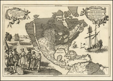
The Second Surviving Example of Philip Lea's Separately Issued Map of North America, Including The Earliest Reference to Daniel Coxe's Carolana Colony and one of the First English Maps to Name the Mississippi River.
Extremely rare map of North America and the Atlantic, originally issued by Thornton, Morden & Lea in 1685, as part of a monumental 6 sheet wall map, known in only a single example. This single sheet was later revised to include "Caralania or Florida" and name the Mississippi River. Burden locates only a single example of each of the two states of this map.
This second state of Lea's map is apparently the earliest printed map to identify Daniel Coxe's Carolana Colony (named Caralania on the map), reflecting Dr. Daniel Coxe's acquisition of the Province of Carolana, comprising a vast section of land west of Florida, extending to the Mississippi River, which had first been granted to Sir Robert Heath in 1629.
The map also provides a virtually unique depiction of the Great R. Mescichipia (Mississippi River), flowing directly from the Great Lakes to the Gulf of Mexico, based upon information apparently derived from the Jolliet-Marquette report of 1681. Cartographically, only one other printed map depicts a similar direct connection, John Thornton's circa 1683 A Chart of the Sea Coasts of Europe, Africa, and America . . .According To Wright's Projection (Burden 578). In naming the Mississippi River, Lea's map is quite possibly the first English map to do so. Only Robert Morden's map of the English Empire (Burden 750), circa 1698 and a second map by Philip Lea (Burden #603) discussed below, both issued about the same time as the present map, also reference the Mississippi, although circumstantially, it would appear that this present map likely pre-dates these other two contemporary imprints.
The Anonymous/Philip Lea Map of America
Burden's The Mapping of America II, #603, describes a map of America which Burden attributes to Philip Lea and provides a date of circa 1684 for the first state, with a second state dated circa 1699. The title of the map is given by Burden as follows:
North America divided into its III principall parts:1st English part viz. English Empire containing ye Articklands near Hudsons bay New North & South Wales New Britain/ N Foundland N Scotland N England N York N Jarsey Pensylvania Marland Virginia Carolina Carolania or Florida California Sommer Is Bahama Is Jamaica & c ye pt viz N France & pt of ye Cariby Is. II Spanish Pt. viz N. Sapin pt. of Ye Antilles III French Pt viz N France & Pt of ye Cariby Is. (emphasis added)
As discussed below, the use of the term "Carolana or Florida" is unique to the Daniel Coxe Carolana Colony. Our research shows no other published use of the name "Carolania or Florida , " the name used by Lea in Burden 603. Clearly, the use was not intended by Lea as a reference to the Province of Carolina, which is the preceding name in the title of Burden 603 and is the place name directly to the right of Caralania on the present map.
While the name Carolana was frequently used between 1629 and 1700 to describe the grant originally made to Sir Robert Heath by King Charles I in 1629, the only use of the name Carolania appears on Burden 603 and the only use of the name Caralania appears on the map we offer here by Philip Lea (Burden 618, state 2). Both maps use the place name "Caralana/Carolania or Florida" to describe a region in the southeastern part of North America, contiguous to the Mississippi River and Gulf Coast. As such, the following would seem highly probable:
- Both maps were issued by Philip Lea
- Both maps were issued circa 1698-99
- Both maps refer to Daniel Coxe's Carolana Colony.
While it is impossible to determine which of the two maps came first, we believe that it is more likely the maps were either issued simultaneously or that Lea first revised this more simplistic map of North America by adding the place name "Caralania or Florida" (the first state of 1684 naming only Florida), while retaining the unusual (and by 1698-99 out of date) course of the Mississippi River (flowing from the Great Lakes in a southwesterly course to the Gulf of Mexico), before creating the more detailed and accurate North America Divided into its III Principal Parts . . . , with a more period accurate depiction of the Mississippi River, based on Coronelli. It is also noteworthy that both maps make use of the abbreviation "Pt" in the titles and each of the maps include a title placed at the top of the map, separated from the rest of the map by two parallel lines below the titles.
In describing North America Divided into its III Principal Parts . . ., Burden speculated that along with a second map of South America contained in the Custis Atlas (Colonial Williamsburg), the North America map quite likely was part of a Thornton, Morden & Lea type multi-sheet, irregular map, for which no copy is known. Burden states:
Here we can speculate on the probable publication of narrow sheets to fill in the gaps created in the left of South America and the right of North America . . . Neither of these postulated sheets has ever been recorded.
We conclude that the present map, revised by Philip Lea, was quite likely intended for inclusion in Burden's hypothesized wall map noted above.
Thornton, Morden & Lea's Legendary 6 Sheet Map of the British Colonies In North America
The present map, first published in 1685, is a part of the story of one of the most fascinating early English Colonial map productions of the 17th Century. Thornton, Morden & Lea's map was the earliest large format map to attempt a general depiction of the British Colonies. Of the six sheets created, two of the sheets would shortly thereafter be re-issued as maps of great historical importance, Thornton, Morden & Lea's A New Map of New England, New York, New Iarsey . . . . and Thornton Morden & Lea's A New Map of Carolina. In both instances, these two maps survive in multiple states dating from 1685 to circa 1715. By contrast, the second state of the map offered here is only known to survive in a a much later composite atlas by George Willdey (see below). The first state of this chart, part of the only known example of the complete 6 sheets, can be seen here: gallica.bnf.fr/ark:/12148/btv1b530327048/f4.zoom
As noted by Burden in his Mapping of North America II (entry 616),
In May 1685, John Thornton, Robert Morden & Philip Lea advertised for sale a multi-sheet map entitled A New Map of the English Empire in the Continent of America. Although earlier multi-sheet maps of the Americas existed, namely the Augustine Herrman of 1673[74], none survive that were of the entire English colonies in North America. In producing the map the publishers were rather too clever. They had the idea of designing a map in a manner in which two of the sheets covering the populated coastlines could also be sold individually. This required the production of variously sized sheets to occupy the required spaces as the Atlantic coastline trends somewhat diagonally across the map. These extra sheets survive in just one known example . . .
Continuing in his entry 618 (this map), Burden notes:
The general map of the Atantic Ocean on Mercator's projection was produced to fill in a gap in John Thornton, Robert Morden & Philip Lea's multi-sheet wall map described [in entry 616]. . . . Unlike two of its neighboring sheets, it does not appear to have been separately issued at the time and would not warrant a listing here were it not for the fact that it too came into the hands of George Willdey. On 3 February 1732 he advertised in the Daily Post that '70 Maps on one Sheet each are as good as ever were done of the Size . . . No atlas was ever referred to in the advert but the author over the years has come across two with exactly these contents, both now unfortunately disbursed. They contain . . . this [map] bearing [the imprint] of Philip Lea.
There are some interesting features including the curious anomaly illustrating the junction of the Mississippi River with the Great Lakes. The river runs directly north-east from its mouth, a feature which must derive from Thornton's awareness of the results of the voyage of Louis Jolliet and Jacques Marquette first published in 1681. The area of the Great Lakes is possessed by a system of Rivers and smaller lakes. All are derived from Thornton's earlier charts of c. 1683. The second state by Lea bears a newly engraved title . . . Further changes include the naming of the Mississippi River and the extension to the name Florida which now reads Caralania or Florida. The Brittish Ocean, Azore Islands, Canaria Islands and Cape Verde Islands are all now named.
In addition to the changes noted by Burden, it appears that in the second state that Lea has added two boundary lines, one between Pennsylvania and Maryland and one marking the southern limits of Carolina.
While the course of Lea's depiction of the Mississippi is similar to the 1683 Thornton, the treatment of the St Lawrence River and the direction of the Mississippi River and the placement of the Great Lakes are significantly different in this chart.
Caralania & The Carolana Grant
Lea's map identifies "Caralania or Florida" as a large region in the South, west of Florida. We can find no other reference to the name Caralania. As noted above, the name is almost certainly a reference to the Carolana Grant, originally granted on October 30, 1629, by King Charles I, to Sir Robert Heath, the King's Attorney General from 1625 to 1631, although the present usage would almost certainly reference the acquisition of the region by Daniel Coxes in 1696.
The original Carolana grant covered the territory between 31° and 36 ° North latitude, covering the areas from about thirty miles north of the Florida state line to the southern side of Albemarle Sound in North Carolina, essentially all of Georgia, the Carolinas, Mississippi, Alabama and Tennessee. The following year Sir Robert Heath conveyed this land to Samuel Vassall and others, who explored it, and made an ineffectual attempt to settle the area.
By 1632, Henry Lord Maltravers claimed the area as the Province of Carolana under an alleged grant from Heath and by the Harvey Patent issued by the Governor John Harvey of Virginia. The Harvey Patent established Maltravers' claim to the area south of the James River known as Norfolk County. No effective settlement was established, although between 1629 and 1640, there were numerous attempts by different parties to advance settlements in the Province of Carolana.
By November 1645, Robert Heath had been formally stripped of all of his possessions, in connection with the English Civil War. The pursuit of settlement of Carolana continued. Notably, several manuscript maps attributed to John Ferrar reference Carolana in the early 1650s.
In 1663, King Charles II granted a new charter to eight Lords Proprietors. Soon thereafter, Lord Maltravers' heirs, the Duke of Norfolk and Samuel Vassall, filed counter-claims, and the Cape Fear Company added its name to those contesting title by the new eight Lords Proprietors. On August, 1665, the Privy Council confirmed King Charles II's more recent grant and declared all previous grants to be null and void.
Daniel Coxe's Carolana
Despite the voiding of the grant, the grant by Sir Robert Heath to Lord Maltravers, et al., was later conveyed in 1678 to James Hays, by Henry Duke of Norfolk, and from Duke to Sir James Shaen, whose heir, Sir Arthur Shaen, conveyed the title in June 1696, to Dr. Daniel Coxe.
According to Cumming, the land Coxe claimed began at the western edge of Carolina and ran to the Mississippi River. Dr. Daniel Coxe (1640-1730) was a physician, natural philosopher and colonial adventurer, who served as the physician to King Charles II and Queen Anne. Before the Carolana Grant, Coxe purchased one million acres of land in west New Jersey in the mid-1680s and served nominally as its governor, although he never left England. After selling the bulk of his holdings to the West New Jersey Society of London in 1692, Coxe shifted his interests further south, acquiring title to the province of 'Carolana' from the heirs Sir James Shaen.
By 1698, Dr. Coxe had begun an aggressive campaign with the English Government to validate his claim to Carolana. In connection therewith, his plans for a settlement in the Mississippi Valley were set forth. Coxe entered into an agreement in May 1698, with Sir William Waller, Olivier de la Muce and Charles de Sailly, providing that the latter would create a colony in Carolana. The colony intended was a settlement of French Hugenot refugees, led by Charles de Sailly, the fourth of five such settlements undertaken by de Sailly. In October 1698, two ships were sent by Coxe and de Sailly, one of which successfully reached Charleston. From there, the settlers transferred to the Carolina Galley and left Charleston in 1699, rounded Florida, and reached the mouth of the Mississippi River, where they began the trip northward. On August 29, 1699, shortly after beginning to ascend the river, they encountered the French ship Renommee, commanded by Bienville. Bienville seized maps and documents from the expedition and forced it to turn back down river. The evidence of the English incursion up the Mississippi River was transferred back to Paris and forms yet another fascinating chapter in the life of Daniel Coxe.
Before the news of the Carolina Galley expedition returned to London, Coxe and his colleagues had turned their colonization interests to Jamaica and Norfolk County, Virginia, the latter of which had been a part of the Carolana grant which Coxe had pressed.
In his son Daniel Coxe's book, published in 1722, the younger Coxe describes the first English exploration of the Mississippi Valley and gives the first English account of Louisiana. He encourages settlement in this area in opposition to the parallel activities of the French, and distinctly seeks to expand English colonization away from the Atlantic coast. DAB further credits Coxe with being the first to publish a plan for the political union of the North American colonies.
Rarity / Surviving Copies of Lea's Map of North America & The Atlantic
Burden noted that only 1 example of the present map was known to survive, although his research accounted for a second example which had been disbursed at an earlier date. We noted in 2015 when this description was originally written that the National Archives of Canada reported a copy of the map in their on line holdings, but as of 2022, this information was no longer accessible on line when we learned that our prior link to the map was no longer working.
As such, the present example is likely either the second or third known example of this map.
Conclusion
The present map is almost certainly the earliest printed map to record the activities of Daniel Coxe in his pursuit of the Carolana Colony.
While it is certainly susceptible to speculation, we were unable to find any formal connection between Philip Lea and Daniel Coxe which would support the notion that Coxe specifically enlisted Lea to publish a map, although the reports of Coxe's presentations to the Board of Trade in support of his claims specifically notes that he had in his possession two maps. As noted by Frank E. Melvin in Notes and Documents Dr. Daniel Coxe and Carolana, The Mississippi Historical Review, Vol 1, No. 2 pp. 257-262 (Sep 1914). In this work, Melvin reviews the import of the recent discovery of a draft revision to the official version of Coxe's presentation of his claim to the Board of Trade in 1699, which exposed a significant error in prior scholarship regarding Coxe. He then summarizes the actions of the Board of Trade and Coxe in 1718, at which time the Board was looking with much greater favor on Coxe's claim for recognition of his title to Carolana.
Coxe first attended [a meeting of the Board of Trade] on July 24 [1718], bringing with him the deeds to his grant, two maps and a demonstration of English rights to Carolana alias Florida . . .
On August 9, the board took under Consideration Coxe's "memorial," his earlier (1699) memoir "Intitul'd: A demonstration of the Right of the King of Englands just pretensions to the province of Carolana Florida and of the present proprietary under his Government; and also his Proposals."
While no formal connection has been found between Lea and Coxe (or evidence to so support the existence of a printed version of Coxe's 1699 presentation), given the appearance of the title Carolania or Florida on Lea's map of North America (Burden 603), and the appearance of Caralania or Florida in this map (Burden 618), it seems fairly certain that the use of these names coincide with the initial flurry of activity created by Coxe in 1698-99 regarding his claim to proprietary ownership of Carolana and his then active attempt to plant an English colony in the Lower Mississippi region based upon such claim, as well as being correctly reflective of the correct dating of these two maps (circa 1698-99).
Philip Lea (fl. 1683-1700) was a central figure in the London map community at the end of the eighteenth century. He apprenticed under Robert Morden, with whom he later collaborated. Lea was made free of the Weavers Company in 1689. He was a publisher and a globe and instrument seller with ties to members of government. For example, Samuel Pepys lists him as his map advisor and colorist. He was not known primarily for his own original works, but for his reworking and reissuing of the work of others, particularly the county maps and world map of Christopher Saxton. He also acquired plates from John Seller, John Ogilby, and William Morgan, among others. Later in his career, he collaborated frequently with Herman Moll. After his death in 1700, Philip’s wife, Anne, carried on the business for several decades.

![L'Amerique Septentrionale Divisée en ses Principaux Etats [Sea of the West]](https://storage.googleapis.com/raremaps/img/small/99018.jpg)
![[ United States ] Carte Speciale, Historique et. Geographique De La Republique Des Etats-Unis De L'Amerique Du Nord](https://storage.googleapis.com/raremaps/img/small/98460.jpg)