


|
||

|

|
|

|
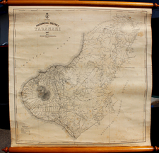
Rare map of the area on the eastern end of the North Island, between Tolago Bay and Poverty Bay and parts in the interior.
The map identifies the Oil Springs and topographical features of the region apparently controlled at the time by New Zealand Oilfields Limited.
Formed in April 1910 for the purpose of developing oil concessions in New Zealand, the company reportedly acquired 44 concessions extending over an area of 230 miles near Gisborne and in the east coast districts.
By September 1913, the company was in receivership and the managing director, George McDonald, had been charged with embezzlement. In an article which appeared in the Launcetown, Tasmania, Examiner, on September 22, 1913, it was reported that:
NEW ZEALAND OIL, OFFICIAL RECEIVER'S REPORT.
LONDON, Sept. 20.
At a meeting of the creditors and shareholders of the New Zealand Oil fields, Limited. the official receiver reported that the prospectus insufficiently disclosed the enormous profits to the promoters. It appeared that the original concessionaire was willing to sell his interest for £50,000, but the company paid £110,750 for it. The company started with a working capital of £52,500. The expenditure includes £7500 to Mr. Macdonald for the acquisition of the Gisborne oil fields, which were dropped, as the report was unfavourable, but Mr. Macdonald retained the cheque.
![A Chart of the South Sea [1st English Map of the Pacific Ocean]](https://storage.googleapis.com/raremaps/img/small/47376.jpg)
![[ New Zealand ] Partie De La Nle. Zelande. Oceanique No. 59 [with] Partie De La Nle. Zelande. Oceanique No. 60](https://storage.googleapis.com/raremaps/img/small/74654.jpg)