|
||

|

|
|

|
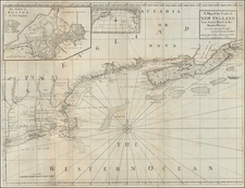
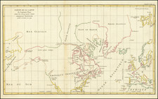
Rare French & Indian War era map of the region between Montreal and Fort Duquesne (Pittsburgh), including all of New York and New Jersey, and most of Pennsylvania. It exhibits a portion of the Theater of War, from Pierre Pouchot's Memoires sur le derniere guerre de L'Amerique Septentrionale.
Pouchot's map provides a remarkable look at the Theater of the French & Indian War in America, as viewed by a French Officer who took part in several important battles and was taken prisoner briefly, following the Siege of Niagara. Illustrations emphasize the topographical features of the region as perceived by Pouchot, and the map provides a remarkable contemporary snapshot of the Pouchot's understanding of the region and his movements in 1759 and 1760.
Montreal is shown in the upper right corner. Along the eastern edge of the map are Lake Champlain, the Connecticut River and Long Island. The map extends beyond Pittsburgh to the west to approximately the area of Sandusky, Ohio and Columbus, Ohio, and showing most of Lake Erie, Lake Ontario and the St. Lawrence River in the north.
One of the most remarkable features of the map is the extensive detail given to the location of roads, which criss-cross the map, offering a fine depiction of the roads known to the French.
The map includes a number of early forts and important battle sites, including Fort Du Quesne (where two sets of crossed swords to the south mark the skirmish with George Washington several years earlier, which is dated 1754 at the bottom of the map, and the site of the Forbes Expedition of 1758, which is marked "Combat de Brando"). The Battle of Ticonderoga is also noted, with the date 1758 shown. Other forts noted include Fort Chougen (Oswego), Fort Niagara, Fort Presque Isle, Fort Cumberland, Ft. La Presentation, Ft. Levis, Fort Chambly, Ft. St. Jean, Fort Carillon, Fort St. Frederic, Ft. William Henry, Fort George, Ft. Hunter, and others.
The present example includes annotations in red which include a series of numbers and the names I. au Citron, I au Cochis (two islands referenced by Pouchot in his journal), and Toniata. These names and numbers also appear in the John Carter Brown copy of the map and would appear to reflect Pouchot's travels up the St. Lawrence, from Monreal toward Lake Ontario, during 1760, after the Siege of Quebec.
The name Toniata dates to 1654, when Pere Simon le Moyne made the first recorded voyage of a European through the upper St. Lawrence. He was sent from Montreal to establish a mission at Oswego. On his way, he stopped at the village of Toniata, where he observed native Mississauga Indians fishing for eel. The site of Toniata is believed to have been on Grenadier Island. During the Seven Years' War, Pouchot visited Grenadier Island, writing
At five leagues from Point au Baril is the Island of Toniata. The main channel of the river is between this island and the south shore. The north part of the river is filled with rushes, and in summer, it is famous for a thriving eel fishery.
M. de Frontenac gave this island to an Iroquois, and the latter sold it for four pots of Brandy to a Canadian, who would have in turn sold it back for a beaver skin.
Grenadier Island is 30 miles south of Chimney Island, then called Isle Royale, which was the site of Fort Levis. It was under the command of Pouchet at the time of the Siege of Thousand Islands, between August 16 and August 26, 1760, by the English, under the command of Brigadier General Jeffery Amherst. After the fall of Quebec in 1759, the English conducted three expeditions against French posts in the interior of French Canada. One ascended the St. Lawrence from Quebec, the second advanced upon Montreal, from Lake Champlain, while the third, under Amherst, came down from Oswego, and encountered on the way the fortifications of Fort Levis, on Isle Royale.
Fort Levis had been constructed during the previous year, 1759, by M. the Chevelier de Levis, on Chimney Island. Following his arrival, Pouchot set about strengthening the fort. The attack on Fort Levis commenced on August 19, and included the British ships Williamson, Mohawk and Onondaga. On August 20, the French sunk the Willliamson and Onondaga, while the Mohawk ran aground. The British Batteries on the neighboring islands continued to lay siege to Fort Levis, until Pouchot's forces ran out of amunition on August 24, 1760.
Streeter calls Pouchet's 3 volume work, published posthumously in Yverdon in 1781, a "contemporary authority of the first importance from the French point of view." Justin Winsor calls this work, "Foremost among the special histories of the war . . . ," and points out its usefulness "in the study of topography, so far as it was known and of the geographical nomenclature of the frontier just previous to the outbreak of the Revolutionary War . . ."
Pouchot, a professional French soldier and engineer, came to Canada in 1755, with the Bearn regiment. He was initially posted to Fort Frontenac (Kingston, Ontario), where the superior quality of the entrenchments which he constructed, led Governor Vaudreuil to entrust him with the rebuilding of the defenses of Fort Niagara. Following exemplary service in the capture of Chouagüen (Oswego) in 1756, Pouchot was appointed by Vaudreuil, on the advice of Montcalm, commandant of Fort Niagara, to be the first officer in the French regular army to hold the post. The first two volumes are the history of the war from 1754 to 1760, including details of Indian warfare and accounts of their manners and customs. The third volume is devoted to a topographical account of Canada.
A fine example of this curious, yet comprehensive map of the region.